The American Exploring Expedition That Changed How We See the World

The American Exploring Expedition That Changed How We See the World
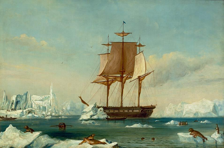
USS Vincennes in Disappointment Bay, Antarctica, during the Wilkes Expedition, circa 1845-1878, attributed to Capt. Charles Wilkes. Public Domain
Dustin Bass
Updated:

The 19th century was the Age of American Expansion. Twenty years after signing the Treaty of Paris in 1783, America signed the Louisiana Purchase, doubling the size of the new nation. A year later, the Lewis and Clark Expedition began. Thirty years after this expedition, a journalist and explorer by the name of J. N. Reynolds stood before Congress and exhorted the political body to sponsor a maritime exploration of the Pacific Ocean and the South Seas.

Reynolds finished his exhaustive speech, stating that Europe “cast her jewels upon the waters, and fortune paid her with a new world, from which has sprung a race of men, who have given new hopes to liberty, when it was nearly lost; and who are now struggling to throw back on Europe, with interest and gratitude, the rays of light we have received from her.”

Secretary of War Joel Roberts Poinsett appointed Lt. Col. Charles Wilkes to lead an expedition of discovery in 1845. Portrait of Joel Roberts Poinsett, Secretary of War, in the administration of Martin Van Buren, by Charles Fenderich. Library of Congress. (Public Domain)
Secretary of War Joel Roberts Poinsett appointed Lt. Col. Charles Wilkes to lead an expedition of discovery in 1845. Portrait of Joel Roberts Poinsett, Secretary of War, in the administration of Martin Van Buren, by Charles Fenderich. Library of Congress. Public Domain

Forming the Great Expedition

A month after Reynold’s address, Congress passed an amendment to the Naval Appropriations Bill, authorizing the president to coordinate an expedition to survey and explore the Pacific Ocean and the South Seas. Political infighting led to delays, but commissioning the expedition finally fell to Martin Van Buren, who would empower Secretary of War Joel Poinsett to organize it.

Poinsett wasted no time in his search for someone to lead the expedition. Lt. Charles Wilkes, the head of the Depot of Charts and Instruments in Washington, D.C., was not his first choice. In fact, Wilkes was Poinsett’s fifth choice.

The 40-year-old naval officer, who would go on to become a rear admiral in the U.S. Navy, was a man of serious intent and indomitable will. He would prove to be exactly what the expedition needed. He calculated his needs, which came out to six ships and 346 men.

Lt. Charles Wilkes led the naval expedition of discovery that embarked in 1838. Lt. Charles Wilkes at the start of the United States Exploring Expedition, 1838–1842, by Thomas Sully. U.S. Naval Academy Museum. (Public Domain)
Lt. Charles Wilkes led the naval expedition of discovery that embarked in 1838. Lt. Charles Wilkes at the start of the United States Exploring Expedition, 1838–1842, by Thomas Sully. U.S. Naval Academy Museum. Public Domain

His ships included the flagship Vincennes, a 780-ton sloop of war; the Peacock, a 650-ton sloop of war; the Porpoise, a 230-ton brig; the Relief, a store ship; and two schooners, the Sea Gull and the Flying Fish. Of his 346 men, there were 82 officers and crew members, and a team of nine scientists, naturalists, and artists. These nine were linguist Horatio Hale, of Harvard; naturalists Charles Pickering, of the Academy of Natural Sciences in Philadelphia, and Titian Peale; Bostonian conchologist Joseph Couthouy; notable Scottish horticulturalist William Brackenridge; botanist William Rich; geologist and mineralogist James D. Dana; and artists James Drayton and Alfred T. Agate.

On Aug. 18, 1838, the United States Exploring Expedition (also known as the Ex. Ex. or the Wilkes Expedition) departed Hampton Roads, Virginia to embark on a four-year surveying and exploring mission that would also be the last circumnavigation of the globe powered fully by sail.

As Secretary of the Navy James Kirke Paulding told Wilkes, it was to be an expedition “not for conquest but discovery. Its objects are all peaceful. They are to extend the empire of Commerce and Science.”

Lithograph of the USS Porpoise, 1836, just before embarking on the United States Exploring Expedition, by J. Baillie, New York, and J. Sowle, New Bedford, Massachusetts. (Public Domain)
Lithograph of the USS Porpoise, 1836, just before embarking on the United States Exploring Expedition, by J. Baillie, New York, and J. Sowle, New Bedford, Massachusetts. Public Domain

From Archipelagoes to Icebergs

The six vessels trekked across the Atlantic Ocean to explore the archipelago of Madeira off the coast of northwest Africa and then the volcanic archipelago of Cape Verde near the west coast of Africa. The Ex. Ex. coasted toward South America, harboring in Rio de Janeiro for about 45 days, and then moved along the coast toward the southern tip of Tierra del Fuego. Wilkes decided to split the six ships into three groups. The Vincennes would survey Cape Horn, and Relief would venture into the Straits of Magellan to survey and describe the various harbors. Wilkes would move his command from the Vincennes to the Porpoise. The Porpoise, with the Sea Gull as tender, would venture southeast toward the Antarctic, and the Peacock, with the Flying Fish as its tender, would head southwest to the Antarctic in hopes of surpassing Captain James Cook’s 1774 exploration. On Feb. 22, 1839, the ships launched.
The Flying Fish in a gale, 1838, by Alfred Thomas Agate, one of the artists on the United States Exploring Expedition. (Public Domain)
The Flying Fish in a gale, 1838, by Alfred Thomas Agate, one of the artists on the United States Exploring Expedition. Public Domain

Wilkes and his crew sighted their first iceberg on March 1. The fall weather had been favorable, but as they floated closer to Antarctica, the weather changed into a milieu of thick fog and harsh gales. While exploring Palmer’s Land, the weather quickly became more hazardous. On March 5, Wilkes and his officers decided to return to Orange Harbor. With the enveloping fog, the Porpoise almost crashed into numerous icebergs and nearly ran aground on Elephant Island.

The Peacock and Flying Fish would encounter more dangers, and even tragedy. An ongoing squall had driven the two vessels apart. On March 11, the Peacock would sight its first iceberg and sustain the first fatality of the expedition when a sailor fell from atop the main topsail into the frigid ocean. Floating through a maze of icebergs, the separated vessels finally reconnected. After two weeks of coasting along the Antarctic, the captains decided to turn back.

In a comparatively less risky venture, the Relief was nearly lost when a storm hit, forcing it to take shelter at Noir Island near the southern tip of Chile. The ship lost both anchors, but managed to reach the next rendezvous of Valparaiso, Chile. The Ex. Ex. would have to try their luck with the Antarctic at a later date.

Wilkes was informed that Peacock had gone to Valparaiso, but was unaware that Relief had gone as well. The Vincennes and the Porpoise sailed north to Valparaiso. Flying Fish and Sea Gull launched a few days later on April 28. Storms battered the two small boats and the Flying Fish escaped back to Orange Harbor, but tragically the Sea Gull was lost with all 18 hands near Cape Horn.

The five remaining ships arrived in Valparaiso. The Relief, no longer seaworthy, returned to America. With only four ships, the squadron sailed across the Pacific, encountering and exploring islands along the way. Their first attempt at landing in mid-August among the Tuamotu Islands was foiled by natives with spears and clubs. Instead of forcing their way on land, the ships sailed on, eventually encountering friendly natives. The scientists and surveyors landed on Tahiti, the Samoan Islands, and the Fiji Islands. By November, the ships embarked to Sydney, where they would visit the continent and surrounding islands, and make plans for a second attempt at the Antarctic region.

A Return to the Antarctic

The day after Christmas 1839, the three largest vessels—Vincennes, Peacock, and Porpoise―headed toward Antarctica. On Jan. 9, Wilkes noted the ships passed Emerald Island, “but saw nothing of it…which I therefore infer does not exist in the locality where it is laid down.” Wilkes was correct. Emerald Island was one of numerous locations noted by previous explorers to not actually exist.
An 1841 map of the Oregon Territory from "Narrative of the United States Exploring Expedition." (Public Domain)
An 1841 map of the Oregon Territory from "Narrative of the United States Exploring Expedition." Public Domain

On Jan. 11, the crew experienced a “thick fog” reducing their vision to a quarter of a mile and “seldom more than the ship’s length.”  On Jan. 16, Wilkes indicated that all three ships sighted land and that “the mountains could be distinctly seen.” There was debate between Wilkes and French explorer, Dumont d’Urville, about who made the discovery first, but the question seems to have been settled in 1910 by Rear Admiral John E. Pillsbury in favor of Wilkes.

The crews sailed along the outskirts hoping to see land at least in intervals to confirm whether the Antarctic was a continent or if it was, as had been assumed, a collection of islands. As the members of the expedition scouted the icy waters and avoided icebergs, a storm was gathering. At 2 p.m. on Jan. 28. Wilkes noticed the air pressure in his barometer drop. Three hours later a gale blew in. The captains shortened their topsails. By 8 p.m., Wilkes noted “very hard” winds and a “violent snowstorm” had descended on the crews rendering their visibility to no more than two ship lengths. “The cold was severe, and every spray that touched the ship was immediately converted to ice.” At 10:30 p.m. the ships were now “thickly beset” by icebergs of which they had “many narrow escapes.” The sails were shortened again. At midnight, Wilkes ordered all hands on deck. Men ran across the iced deck to their positions, as the ship was tossed about by the wind and waves.

“I felt that neither prudence nor foresight could avail in protecting the ship and crew,” Wilkes wrote. “All that could be done was to be prepared for any emergency, by keeping every one at his station.”

The crews struggled to keep control of the vessels, while trying to avoid falling overboard, freezing to death, or crashing into icebergs.

“All hope of escape seemed in a moment to vanish…expecting every moment the crash,” Wilkes noted. “The ship continued her way, and as we proceeded, a glimmering of hope arose, for we accidentally had hit upon a clear passage between two large ice-islands, which in fine weather we should not dare to have ventured through.”

Wilkes and his fellow captains did dare, but as soon as they had passed through and “had escaped an awful death”... they “were again tempest-tost.” It was not until 7 a.m. before “there was some appearance of the weather moderating.” The Ex. Ex. members, finally able to exhale, were “thankful to the Providence that had guided, watched over, and preserved [them].”

By this time, the medical officers made the recommendation to abandon the surveying of the icy region, but Wilkes was adamant. He would not be deterred. The crews saw land again on Feb. 2, but the view would be short-lived. A storm hit that lasted five days. Land was sighted again on the 10th and 12th and for the following days until the 17th. The three ships continued until Feb. 21 but no land was seen. Wilkes believed his Antarctic mission complete. The Wilkes Expedition had officially confirmed a seventh continent.

Dangers in the Pacific Islands

The ships made port in Sydney three weeks later and overhauled their vessels. Rejoined by the Flying Fish, the Ex. Ex. left Sydney for New Zealand, Tongatapu Island, and the Fiji Islands. The schooner was the last to arrive, having hit a reef and tearing away part of its keel. The four ships visited Malolo, but two sailors were killed by island natives. Wilkes stormed the beaches, buried his men, and fought the natives, killing 60 and destroying two villages. The natives sued for peace.

The expedition left the Fiji Islands and arrived in the Hawaiian Islands. The Vincennes remained in Honolulu for the winter. The Porpoise returned to Tuamotu Islands. The Peacock and the Flying Fish returned to the Samoan Islands and also searched for other islands. The four reconvened in Honolulu in March, and on April 5, 1841, the ships set sail for America.

Portrait of naturalist Titian Ramsay Peale in the uniform of the Long Expedition, circa 1819, by Charles Willson Peale. (Public Domain)
Portrait of naturalist Titian Ramsay Peale in the uniform of the Long Expedition, circa 1819, by Charles Willson Peale. Public Domain

Across the Pacific and Back Again

On April 28, the four ships reached the Columbia River off the Oregon coast. “Mere description can give little idea of the terrors of the bar of the Columbia,” Wilkes noted. The scientists, artists, and surveyors scoured the Oregon Country over the next several months.

Disregarding the terrors of the bar, the Peacock attempted to enter the mouth of the Columbia River on July 18, only to meet with disaster. She became stuck and after 24 hours of struggling to free herself, the crew abandoned ship, taking as much of the supplies and scientific artifacts as possible. It was a close-run thing. Every crew member escaped to the nearby Fort George in today’s Astoria, but the Peacock was torn to pieces.

Wilkes arrived and purchased a local brig to replace the Peacock. The ship was renamed Oregon. With a heightened sense of precaution, the Porpoise and the Flying Fish sailed the Columbia River from Aug. 28 to Sept. 14, reaching as far as Fort Vancouver. By this time, the Vincennes was in San Francisco Bay, where it had been exploring the Sacramento River. All four ships left the Bay to cross the Pacific Ocean to explore the Asian territories. The Vincennes and the Flying Fish entered the South China Sea, anchoring in Manila. After Manila, the Vincennes crossed the Sulu Sea and anchored at Suong, the capital of Sulu.

The Vincennes arrived in Singapore, where the other three ships awaited to dispense with the final leg of the four-year voyage. The time lost from the Peacock disaster inhibited exploring Japan. Additionally, the Flying Fish, no longer seaworthy, was sold before sailing toward the final destination of New York Harbor.

The United States Exploring Expedition had begun with six vessels, but would return with three, and only two of the original: the Vincennes and the Porpoise.

The Ex. Ex. Returns

It was a glorious sight when the three ships returned to America, but more glorious were their ecological returns.

The Wilkes Expedition produced 241 charts, mapping out 280 Pacific islands, including for the first time the full group of Fiji Islands. The expedition also mapped out 800 miles of the Oregon coast, 100 miles of the Columbia River, a land route from Oregon to San Francisco, and arguably the most consequential, 1,500 miles of the Antarctic coastline, which confirmed it as the world’s seventh continent.

From their adventures, the group collected more than 4,000 ethnographic pieces, which was a third more than those collected from Cook’s three voyages. The naturalist, Titian Peale, collected 2,150 birds, 134 mammals, and 588 species of fish. The geologist, James Dana, collected 300 fossil species, 400 coral species, and 1,000 crustacea species. There were more than 200 entomological and zoological species collected in jars, and more than 5,000 larger specimens placed in large envelopes. Among the horticultural and botanical collections, William Rich, William Brackenridge, and Charles Pickering assembled an astounding 50,000 specimens of 10,000 different species, with an additional 1,000 living plants and approximately 650 seeds belonging to other species of plants.

As the tens of thousands of items were ushered into the country, the United States government struggled to place them. Poinsett and Paulding decided to place the collections in the 265-foot-long Great Hall of the Patent Office Building in Washington, D.C. The following decade, more than 100,000 people annually visited the “Collection of the Exploring Expedition” in the Patent Office.

In 1858, the Collection found a new and permanent home inside the Smithsonian Institution, now the world’s largest museum, education, and research complex. “Today,” according to the Smithsonian Institution, “the specimens constitute the core of nearly every collection in every scientific department in the National Museum of Natural History.”

Dustin Bass
Dustin Bass
Author
Dustin Bass is an author and co-host of The Sons of History podcast. He also writes two weekly series for The Epoch Times: Profiles in History and This Week in History.
Related Topics