Hong Kong Geo Trails for Nature-goers

The first thing that comes to the mind of a person travelling to Hong Kong would probably be the Peak, Ngong Ping 360, the Ocean Park, or even the Hong Kong Disneyland. But a geological park, and a global one at that?
Hong Kong Geo Trails for Nature-goers
The man-shaped cracks, a landmark on the High Island Reservoir East Dam. Sun Mingguo/Epoch Times
Updated:

The first thing that comes to the mind of a person travelling to Hong Kong would probably be the Peak, Ngong Ping 360, the Ocean Park, or even the Hong Kong Disneyland. But a geological park, and a global one at that? The mere thought that there used to be a supervolcano over 20 kilometres in diameter spreading out from High Island to Tai Long Wan in the north and the Ninepin Group in the south about 140 million years ago is unimaginable. But it is true that during the early Cretaceous Period, the Eastern part of China, including Hong Kong, underwent vigorous volcanic activities. The multiple violent explosions of the ancient supervolcano caused the magma chamber to be emptied, forming a caldera.

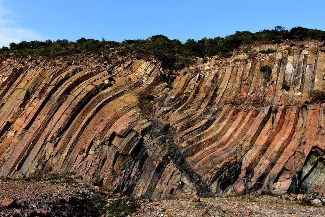
Sharp Island, being located on the margin of the caldera, showcases typical igneous rocks such as volcanic breccia, rhyolite, quartz monzonite (commonly known as the “pineapple bun” of the wild), the volcanic rocks on the High Island are a spectacular geological heritage – the hexagonal rock columns. The discovery of the rock column formation was brought about by the construction of two dams that linked the Rocky Harbour and the Sai Kung peninsular between 1971 and 1978 to ease the water supply shortage problem due to the rapid expansion of the Hong Kong population from the 50s to the 70s.

Hexagonal volcanic rock columns on High Island. (Sun Mingguo/Epoch Times)
Hexagonal volcanic rock columns on High Island. Sun Mingguo/Epoch Times

Hexagonal rock columns are not uncommon around the world. While most of them, such as the Giant’s Causeway in Northern Ireland, are dark-coloured basalt columns with a silica content of about 50%, the ones at the High Island Reservoir are unique in that they are light-coloured acidic volcanic rocks with a high silica content of over 60%. The formation covers an area of about 150 square kilometres (including areas covered by the sea). Each rock column can go as high as 150 metres above the ground with an average diameter of 1.2 metres. It is estimated that there are about 4 million columns on the High Island. The mega scale of the formation puts High Island as well as its surrounding geological heritage on the world map of geolocal parks in 17 September 2011.

Besides the hexagonal rock columns, the High Island Reservoir East Dam has another unique feature – the Coffer Dam which protects the East Dam from coastal erosion. The Coffer Dam has about 7000 concrete dolos, each weighs 25 tons and is piled up randomly.

Sharp Island is easily accessible by a 15-minute boat ride (by kaito) from the Sai Kung Pier. (Sun Mingguo/Epoch Times)
Sharp Island is easily accessible by a 15-minute boat ride (by kaito) from the Sai Kung Pier. Sun Mingguo/Epoch Times

The Hong Kong Global Geopark comprises of the Sai Kung Volcanic Rock Region and the Northeast New Territories Sedimentary Rock Region. The High Island together with Sharp Island, the Ung Kong Group and the Ninepin Group make up the Sai Kung Volcanic Rock Region. Sharp Island is easily accessible by a 15-minute boat ride (kaito) from Sai Kung Pier. As for the High Island Reservoir East Dam, it can be reached by taking bus number 94 from Sai Kung Town to Pak Tam Chung and another 25-minute taxi ride as no other public transport serves the area. Alternatively, one may choose to walk 2.5 hours from Pak Tam Chung.

Courtesy of Hong Kong Geopark and Volcano Discovery Centre.
Special thanks to Amusing Travel Plan Limited and Tour Guide, Frankie Cheung.