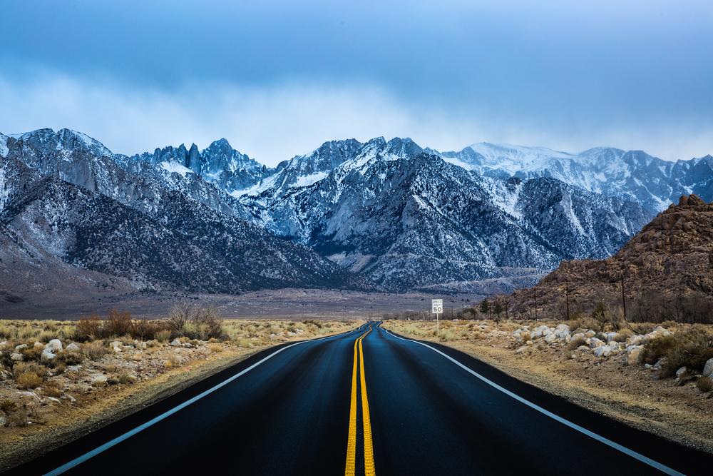
Tahoe seems like a long time ago. With the blacktop slicing through the desert before me, through my windshield—the sole, man-made interruption slashing through this barren, rugged landscape of brown, beige, and the occasional swipe of pink—I descend into the heat.
Around me, I can almost feel the thermals rising from the bottom of the valley, despite the fact that I’ve cranked the AC to the max. Ahead, sits Badwater Basin, the ultimate low—on this route, and in the entire country. It’s the end point of a trip that’s been filled with so many highs, all along the way.
It’s the best road trip you’ve never heard of. A mostly two-lane highway unraveling across the quiet side of California, U.S. Route 395 stretches from South Lake Tahoe to Death Valley, rolling through forests, mountains, lakes, and sands, winding through the Eastern Sierra Nevada, the Mojave Desert, and across the flanks of Mount Whitney—the tallest peak in the continental United States. In between, you’ll find so much of what makes the open road special, from ghost towns to ski resorts to small villages with big surprises.
And the best part? You might just have the whole thing to yourself.
Lake Tahoe
Straddling the California-Nevada border, this mile-high body of water (altitude at the surface is more than 6,000 feet, and depths below can reach to 1,000 feet) is the largest alpine lake in North America. But, of course, it’s a lot more than that. Long a favorite getaway spot for city-bound Northern Californians, its cold waters and cool pines provide relief in the summer, with nearby slopes and trails hosting skiing, snowboarding, and snowshoeing in the winter. And on the Nevada side, it all feels a little like a scaled-down Vegas (albeit surrounded by forest). Start here, then turn south, down the 395, in search of gold.
Bodie
Once home to thousands of hopeful souls, this gold-rush town boomed in the second half of the 19th century, with hundreds of restaurants, some five-dozen saloons, and even a horse-racetrack keeping miners occupied. It was a true Old West place, with gunfights on the dusty streets of the red light district. Now a state historic park, it still maintains that feel—if you squint your eyes, just a little bit, you can travel back in time, more than a century.
With many structures still standing but left in a state of “arrested decay,” kept as close to the shape and form they embodied when the town passed into government hands in 1962, you can peek through the windows and note that things look a little like everybody may have left the building, just a moment ago—place settings left undisturbed, still sitting there on dinner tables, as well as roulette wheels, all ready to spin, just waiting for a little action.
Mono Lake
Strange and beautiful, this ancient lake (pronounced MO-no), right along the route, has a very high degree of salinity, which results in a number of unique manifestations. One of them—birds. Because of all the salt, Mono has a flourishing ecosystem of brine shrimp, which attract as many as 2 million migratory fowl, a paradise for birdwatchers. Another: the Tufa Towers, a series of white calcium carbonate natural structures rising out of the water—some of themlike a set of irregular teeth—glimmer white in the sun, growing to a height of about three stories. Drive down to the shore along a twisting road, take your photos, then proceed back down the 395.
Mammoth Lakes
Between Mono and Mammoth, you’ll skirt the back door of famed Yosemite National Park—worth a stop, before you head further south. Small but mighty (home to about 8,000 people), Mammoth Lakes is a true California ski town, home to the highest chairlift-serviced peak in the state. But even if you’re not eager to strap on skis, or a snowboard, there’s plenty here to keep you occupied. Find a few waterfalls (Rainbow Falls, for example, plunges 101 feet in a shimmering cascade), then tour the Gallery at Twin Lakes, built back in the 1930s by artist Stephen H. Willard, who painted iconic scenes of the West. Come here to view his works, as well as his home—it all still feels very lived-in, in all the best ways, in part because the current owners still spend their summers here, and welcome visitors inside.
Mount Whitney
Branch off the main highway to wind through dense forest and white-knuckle switchbacks, each curve presenting a new, breathtaking, sweeping view to a trailhead that leads to its frosty, 14,500-foot summit—the highest peak in the contiguous United States. Even the parking lot sits at 8,300 feet. You may not be geared to make the difficult ascent, all the way to the apex, but you can still take the first few steps along the path, and then visit a rustic souvenir shop where the person behind the cash register will share a few memorable stories about those who have attempted to do so, with (often) mixed results.
Lone Pine
If this place looks familiar, there’s a very good reason for that. Rolling into town, you might recall a few famous scenes from the literally hundreds of movies filmed here. The surrounding Alabama Hills have served as the setting for some 400 feature films. Take a self-guided tour of these monzogranite boulders, where John Wayne rode high in a dozen different movies, where both “Gladiator” and “Star Wars” were given memorable moments, and where Humphrey Bogart perished in “High Sierra.” Then head back to town to spend time in the truly remarkable Museum of Western Film History, which commemorates the classics, as well as more recent favorites.
Death Valley National Park
From some of the highest altitudes in the country, now the 395 descends into the desert, taking you to the lowest point in North America, the driest of all national parks, and the hottest place in the world—100 F in Death Valley is pretty typical, and back in 1913, thermometers here rose to a shocking 134 F. Walk out on the salt flats at Badwater Basin, which glimmer under the sun at 282 feet below sea level, then get back into your car for one, final, spectacular vista, at Dante’s View. Sitting at 5,000 feet, the expanse of the super-heated valley spreads before you, and, on a clear day, you can see all the way back to the snow-capped peak of Mount Whitney—the perfect place to reflect on your journey.
Toronto-based writer Tim Johnson is always traveling, in search of the next great story. Having visited 140 countries across all seven continents, he’s tracked lions on foot in Botswana, dug for dinosaur bones in Mongolia, and walked among a half-million penguins on South Georgia Island. He contributes to some of North America’s largest publications, including CNN Travel, Bloomberg, and The Globe and Mail.
Tim Johnson
Author
Toronto-based writer Tim Johnson is always traveling in search of the next great story. Having visited 140 countries across all seven continents, he’s tracked lions on foot in Botswana, dug for dinosaur bones in Mongolia, and walked among a half-million penguins on South Georgia Island. He contributes to some of North America’s largest publications, including CNN Travel, Bloomberg, and The Globe and Mail.