NASA Video Shows Monster Hurricane Dorian As Seen From Space

NASA Video Shows Monster Hurricane Dorian As Seen From Space
Hurricane Dorian viewed from the International Space Station on Sept. 1, 2019.Courtesy of NASA/YouTube
Richard Szabo
Updated:

The national space agency released moving images from outer space showing the path of a dangerous weather system bound for Florida on Sept. 1.

National Aeronautics and Space Administration (NASA) has published a video filmed from the International Space Station, showing Hurricane Dorian moving closer towards the eastern coast of Florida.
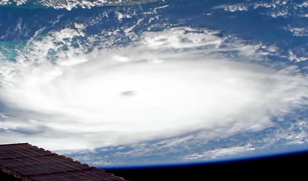
“It churned over the Atlantic Ocean over the northern Bahamas,” NASA said on YouTube.

The footage shows close up views from different angles of the category 5 system, which clocked life-threatening wind speeds, according to NASA. The footage was recorded at 12:16 p.m. eastern time at an an altitude of 260 miles.

“The storm, which is moving in a westerly direction with sustained winds of 180 miles an hour, is a dangerous category five hurricane, carrying the strongest winds in recorded history for the northwestern Bahamas,” NASA said.

The video has already been viewed more than 49,000 times and liked over 2,000 times.

The agency confirmed the hurricane is causing “catastrophic damage” to the Abacos and Grand Bahama Islands, according to a National Hurricane Center advisory published at 11 a.m.

The Associated Press (AP) revealed the storm tore off roofs, overturned cars, and removed power lines while islanders took refuge in schools, churches and shelters.

In the northern stretches of the archipelago, hotels were closed and residential homes boarded up as officials hired boats to move people to larger islands. Floodwaters rushed through the streets of an unidentified town at nearly the height of a car roof according to a video Jibrilu and government spokesman Kevin Harris claim to be sourced from Abaco residents.

In some parts of Abaco, “you cannot tell the difference as to the beginning of the street versus where the ocean begins,” Bahamas Prime Minister Hubert Minnis told AP.

The hurricane first made landfall at Elbow Cay on Abaco island about 12:40 p.m. local time before moving to Marsh Harbour at 2 p.m.

“It’s devastating,” Bahamas Ministry of Tourism and Aviation Director General Joy Jibrilu told AP. “There has been huge damage to property and infrastructure. Luckily, no loss of life [was] reported.”

With wind gusts up to 220 mph, Hurricane Dorian matched the current record for the most powerful Atlantic hurricane ever to reach the shores—the Labor Day hurricane of 1935.

The Bahamas government has opened 14 shelters and blamed dozens of locals for ignoring evacuation orders.

“The end could be fatal,” Assistant Police Commissioner Samuel Butler told AP. “We ask you, we beg you, we plead with you to get to a place of safety.”

Meanwhile South Carolina Gov. Henry McMaster (R) has ordered a mandatory evacuation of the entire coast of the Palmetto State. The order affects about 830,000 residents from noon on Sept. 2. State troopers will assist the evacuation by reversing lanes to allow residents to head inland on major coastal highways.

“We can’t make everybody happy but we believe we can keep everyone alive,” McMaster said.

Authorities separately ordered mandatory evacuations in some vulnerable coastal areas of Florida and canceled more than 600 Labor Day flights across the United States as of Sept. 1.

Associated Press contributed to this report.
Richard Szabo
Richard Szabo
Editor/Reporter
Richard Szabo is an award-winning journalist with more than 12 years' experience in news writing at mainstream and niche media organizations. He has a specialty in business, tourism, hospitality, and healthcare reporting.
Related Topics