Ernesto Approaches Bermuda, Strengthens to Category 2 Hurricane

‘Preparations to protect life and property should be rushed to completion,’ warns the National Hurricane Center.
Ernesto Approaches Bermuda, Strengthens to Category 2 Hurricane
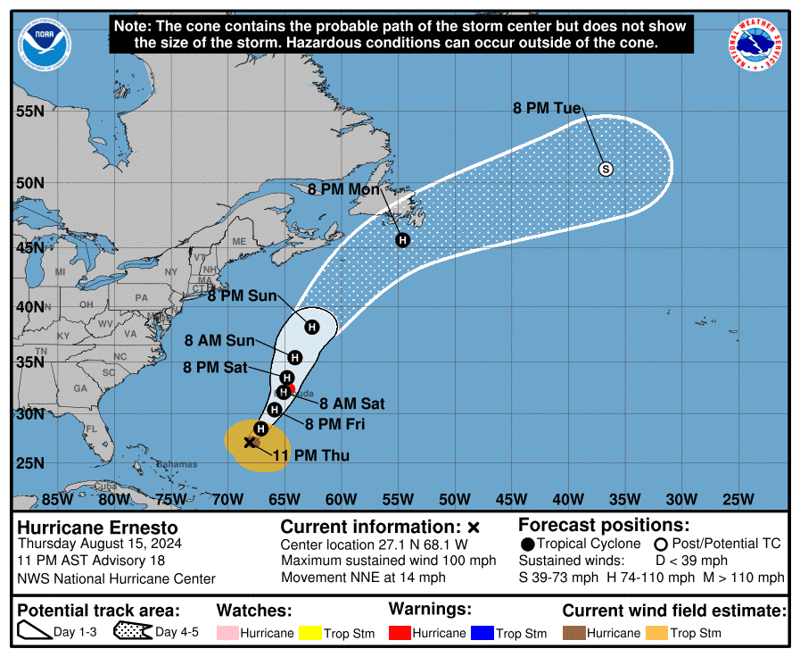
The National Hurricane Center's projected track of Hurricane Ernesto as of 11 p.m. AST on Aug. 15, 2024. National Hurricane Center/National Weather Service
T.J. Muscaro
Updated:
0:00

Bermuda is expected to begin facing tropical storm conditions on Aug. 16 as Hurricane Ernesto nears the island, according to the National Hurricane Center (NHC).

The storm is expected to bring a “prolonged period of strong winds and storm surge on Bermuda from Friday afternoon through Saturday night,” the NHC stated in its 11 p.m. advisory on Aug. 15.
The NHC urged residents to protect their properties. Rainfall overnight could cause flash flooding from Friday through the weekend.

Swells generated by the storm may cause life-threatening surf and rip currents in Turks and Caicos, the Bahamas, and Atlantic Canada over the next few days, the NHC said.

Ernesto strengthened to a Category 2 hurricane, with increased sustained winds of 100 mph.

Hurricane-force winds (74 mph or greater) extend 60 miles from the storm’s center, and tropical storm-force winds (39 mph–73 mph) extend as far as 265 miles.

Ernesto is expected to pass near or over Bermuda on Aug. 17. However, it is expected to intensify further before that happens.

“Additional strengthening is forecast during the next day or so, and Ernesto could be near major hurricane strength on Friday, the NHC stated in its 11 p.m. advisory.
The NHC’s forecast advisory predicts Ernesto could be a borderline Category 3 hurricane by early afternoon on Aug. 16.

It will reach maximum sustained wind speeds of 109 mph with gusts of up to 132 mph before gradually decreasing intensity to 92 mph winds by Aug. 17.

The Saffir-Simpson Hurricane Wind Scale gives a Category 2 hurricane sustained winds of 96 mph—110 mph. A Category 3 hurricane has winds of 111 mph—129 mph.

A hurricane warning is in effect for Bermuda.

Rainfall of six to 12 inches is expected, with some areas possibly getting as much as 15 inches, which could result in flash flooding.

Dangerous storm surges accompanied by large and destructive waves are also expected, according to the NHC.

Ernesto is moving north-northeast at 14 mph, having turned after delivering hurricane-force conditions and several inches of rain to Puerto Rico and the U.S. Virgin Islands. This general motion is expected to continue through Aug. 16, before a slower north-northeastward motion on Aug. 17.

St. Croix suffered an island-wide blackout, and more than 600,000 people were reported without power on Aug. 14.

More than 20 hospitals in Puerto Rico were reported to be operating on generators.

“A lot of rain, a lot of rain,” Culebra Mayor Edilberto Romero told the Associated Press. “We have trees that have fallen on public roads. There are some roofs that are blown off.”

The Caribbean is not out of the woods yet with severe flooding reported across Puerto Rico.

The NHC reported swells causing life-threatening surf and rip currents generated by Ernesto are affecting Turks and Caicos, and the Bahamas.

Those swells will spread to Bermuda and are expected to bear down on the U.S. coastline through the weekend.

“Residents need to prepare now before conditions worsen,” said Bermuda’s National Security Minister Michael Weeks. “Now is not the time for complacency.”

Caden Pearson and The Associated Press contributed to this report.