About 100 million people are under a winter storm watch, advisory, or warning, according to the National Weather Service.
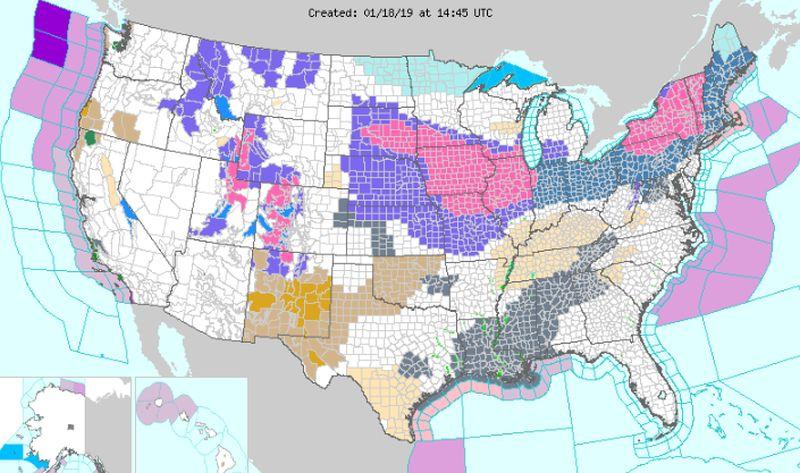
The storm is slated to intensify late on Saturday, Jan. 19. When that happens, “Heavy snow is forecast to develop and rapidly overspread the Ohio Valley, reaching much of New England early on Sunday,” the agency warned on Jan. 18
“The storm is expected to become quite intense on Sunday as its center passes near or just south of New York City. Conditions over interior New England could approach blizzard criteria as the storm brings very strong northerly winds together with heavy snow,” the NWS said.
Meanwhile, this storm should bring some rain, sleet, and ice to go with the snowfall.
But on Friday, the major metropolitan areas on the East Coast will see light snow. However, overall accumulations in places like New York City and Boston should be low before the more significant storm hits on Saturday.
CNN reported that as of Friday, 450 flights had been canceled across the United States.
“While the heaviest total snow accumulation from the storm will fall north of the Interstate 95 cities from Washington, to Baltimore, Philadelphia, New York City and Boston, enough wintry precipitation can occur in the heart of the cities or just northwest to cause slippery conditions and major travel disruptions,” it continued.
Arctic Blast
On Sunday night and Monday, temperatures across the East Coast are expected to plummet to 15 to 25 degrees below normal, and some places might get below 0 degrees Fahrenheit.Midwest
The storm should bring 2 to 8 inches of snow from South Dakota to northern Ohio, with up to 10 inches in northern Iowa, according to National Weather Service maps. The agency posted winter storm warnings Thursday afternoon in South Dakota and Iowa and winter storm watches all the way to New England, where accumulations could top 12 inches, Reuters reported.Temperatures on Sunday were expected to dip to 1 degree Fahrenheit (minus 17 degrees Celsius) in Des Moines, Iowa, around 8 F in Chicago and minus 4 F in Lansing, Michigan. Winter wheat is most resistant to cold in January and generally should be able to withstand sub-zero temperatures for a few hours.
The storm should bring 2 to 8 inches of snow from South Dakota to northern Ohio, with up to 10 inches in northern Iowa, according to National Weather Service maps. The agency posted winter storm warnings on the afternoon of Jan. 17, in South Dakota and Iowa and winter storm watches all the way to New England, where accumulations could top 12 inches.
The snowfall may complicate the transportation of livestock but should help insulate dormant winter wheat from cold air expected in the storm’s wake.
Temperatures on Sunday were expected to dip to 1 degree F in Des Moines, Iowa, around 8 F in Chicago, and minus 4 F in Lansing, Michigan. Winter wheat is most resistant to cold in January and generally should be able to withstand sub-zero temperatures for a few hours.
Streit and others said forecast models predict a blast of Arctic air around Jan. 28 to 29 that threatens to push temperatures below zero degrees F in the Plains, Midwest and possibly into northern Delta wheat states like Arkansas and Tennessee.
“It’s very unusual for them to see sub-zero readings, but this is one that does carry that potential,” Streit said.
Livestock and Crops
The snowfall may complicate the transportation of livestock but should help insulate dormant winter wheat from cold air expected in the storm’s wake.However, portions of the northern Midwest may miss the snow. Some 15 to 20 percent of the region’s soft red wheat crop may be at risk of winterkill early next week, the Commodity Weather Group said.
Livestock may be more vulnerable, especially given expectations for Plains temperatures to remain below normal through much of the next 15 days.
“That’s what gets hard for livestock. It’s sort of a cumulative effect. You cut back on any weight gains during that time period, and you'll have some outright losses, I would guess, in some of the more significant cold air outbreaks,” Commodity Weather Group meteorologist David Streit said.