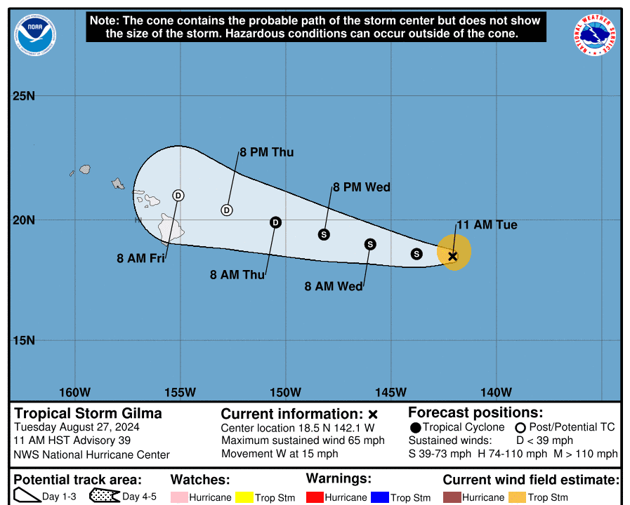
Heading toward Hawaii, Gilma dropped from a strong Category 2 hurricane to a tropical storm in the last 24 hours, according to the National Hurricane Center (NHC).
“Gilma should continue to weaken over the next 36 hours as it remains located within an environment of ... roughly 17 to 20 mph of westerly wind shear, dry air, and within sea-surface temperatures of 25 to 26°C (77 to 78.8°F),” the NHC stated in its 11 a.m. forecast discussion.
“In about 48 hours, Gilma should move into an area of even stronger westerly wind shear, which will lead to any remaining convection being stripped away,” the NHC added.
Positioned 850 miles east of Hilo, Hawaii, moving west at 15 mph, Tropical Storm Gilma is expected to become a “remnant low” by Aug. 29. The National Weather Service defines a remnant low as a post-tropical cyclone with winds less than 39 mph and no longer having the organized convection of a tropical storm.
Projected tracks from the NHC show Gilma passing north of the Island of Hawaii, referred to as “The Big Island,” and drawing close to Maui around 8 a.m. local time on Aug. 30.
“The remnants of Gilma may bring heavy rainfall to portions of the Hawaiian Islands as early as Friday, lasting through Saturday,” the NHC forecast.
The rain might be a welcomed event.
“We are hoping for the rain now to kind of update the drought conditions we have on the leeward side of the island,” Ian Morrison, forecaster at the National Weather Service’s Honolulu office, told The Epoch Times on Aug. 26.
Easterly swells generated by the approaching storm “may produce high surf along east-facing shores of some islands” from Aug. 28 through Aug. 30.
No watches or warnings have been issued yet for the islands.
Gilma could be the second named storm to affect the Hawaiian Islands in as many weeks, following Hurricane Hone—now a tropical storm—which passed south of the archipelago on Aug. 25, dispensing heavy rains and 70 mph winds to parts of the Big Island.