Tropical Storm Gordon Forms in Atlantic

The Atlantic’s seventh named storm of 2024 currently poses no threat to land.
Tropical Storm Gordon Forms in Atlantic
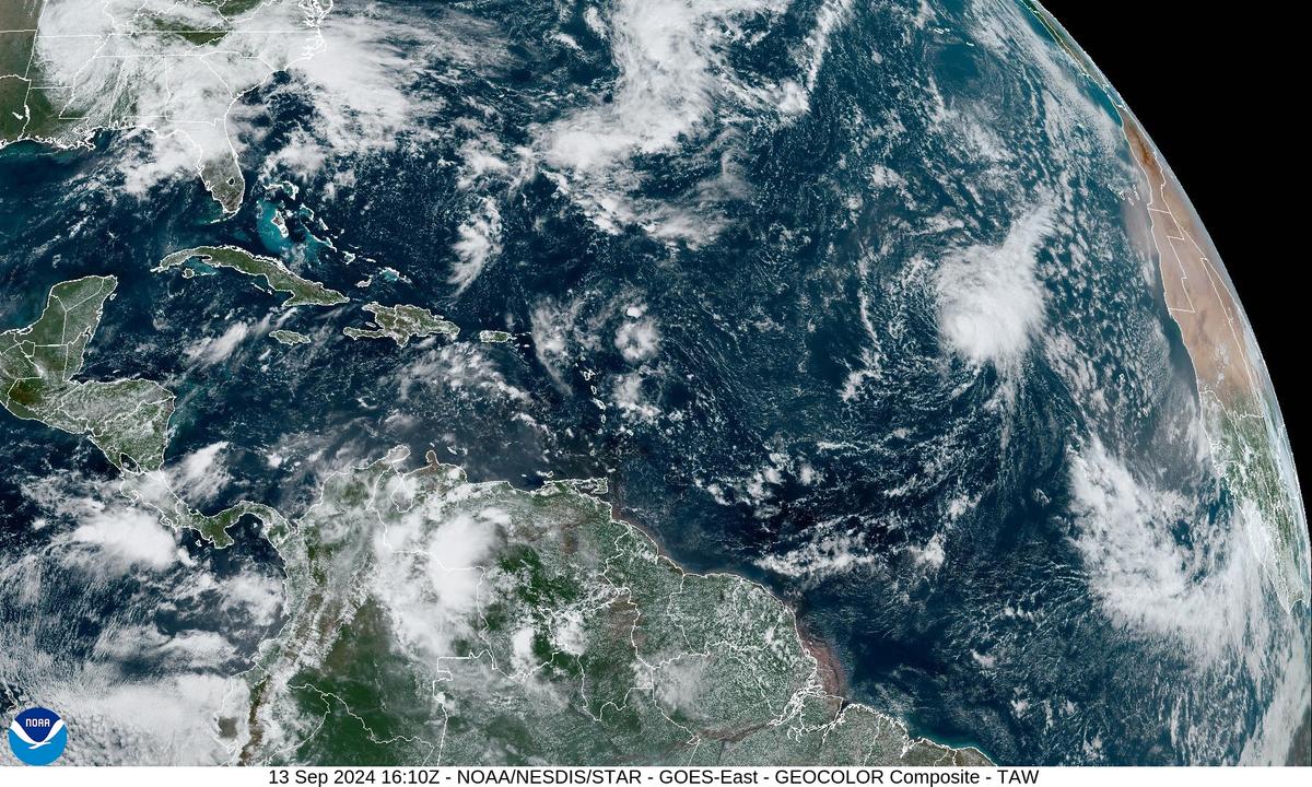
Satellite imagery of Tropical Storm Gordon (R) in the Atlantic Ocean as of 11:10 a.m. EST on Sept. 13, 2024. NOAA/NESDIS/STAR/GOES
T.J. Muscaro
Updated:
0:00

Tropical Storm Gordon formed in the mid-Atlantic on the morning of Sept. 13, according to the National Hurricane Center.

It is the Atlantic’s seventh named storm for the 2024 hurricane season and appeared two days after Hurricane Francine made landfall in Louisiana. The Atlantic hurricane season runs from June 1 through Nov. 30.
Unlike Francine, Gordon poses no immediate threat to land.

As of 11 a.m. ET on Sept. 13, it is still less than 1,000 miles away from the Cabo Verde Islands, off the coast of Africa, and is moving west-northwest at 12 mph.

Tropical storms boast maximum sustained winds of at least 39 mph, and the National Hurricane Center registered Gordon to have 40 mph winds, with winds at least 39 mph extending out 70 miles from its center.

Forecast tracks predict Gordon will drop back down to a tropical depression by Sept. 15 and regain tropical storm status a few days later. By Sept. 18, it will still be well east of the Windward Islands.

In order for a storm to earn a name, it must reach both a certain wind speed and a certain amount of organized convection.

A typical Atlantic hurricane season produces 14 named storms, 7 of which are hurricanes and 3 of which are major hurricanes, according to the National Oceanic and Atmospheric Administration (NOAA). Many never make landfall.

In 2023, 11 of the season’s 19 named storms never touched land or triggered a hurricane warning.

Hurricane Francine and Tropical Storm Gordon appeared after a rare three-week pause in storm activity that ran through Labor Day Weekend.

“Overall, the tropics (Atlantic basin) are starting to awaken from the slumber we have had for the last few weeks,” Stan Goldenberg, a meteorologist for the Hurricane Research Division at NOAA’s Atlantic Oceanographic & Meteorological Laboratory, told The Epoch Times in an email on Sept. 5.

“We are still seeing a lot of dry air inhibiting activity, but that normally starts to clear out about this time so it is expected to change soon,” he said.

The National Hurricane Center stated that it expects Gordon to move into a part of the tropical Atlantic described as having a “moisture-starved environment” on Sept. 13. That environment will cause the storm to weaken.

Still, NOAA predicts the 2024 season has a 90 percent chance of having higher-than-normal activity, with 17 to 24 named storms (winds of 39 mph or higher), 8 to 13 of them being hurricanes (winds of 74 mph or higher) and 4 to 7 being major hurricanes, in its Aug. 4 report. A major hurricane is Category 3 or stronger with wind speeds of 111 mph or greater.

Remnants of Hurricane Francine are expected to continue to deposit several inches of rain across the southeast U.S. from Florida through Alabama and up to the Tennessee Valley over the next few days. Flash and urban flooding also remain a risk for those areas.

T.J. Muscaro
T.J. Muscaro
Author
Born and raised in Tampa, Florida, T.J. Muscaro covers the Sunshine State, America's space industry, the theme park industry, and family-related issues.