Hurricane Warning Issued for Louisiana Gulf Coast as Tropical Storm Francine Strengthens

Francine is expected to make landfall as a Category 2 hurricane with maximum sustained winds of 100 miles per hour.
Hurricane Warning Issued for Louisiana Gulf Coast as Tropical Storm Francine Strengthens
The National Hurricane Center’s projected track of Tropical Storm Francine as of 4 p.m. CT on Sept. 9, 2024. National Hurricane Center/National Weather Service
T.J. Muscaro
Updated:
0:00

A hurricane warning has been issued for parts of the Louisiana coastline as Tropical Storm Francine continues to intensify in the Gulf of Mexico and appears to be headed toward the southern state several hours earlier than previously expected.

An advisory issued by the National Hurricane Center (NHC) at 4 p.m. Central time on Sept. 9 projects that the eye of Francine will make landfall as a Category 2 hurricane at roughly 1 p.m. on Sept. 11, with maximum sustained winds of 100 miles per hour.
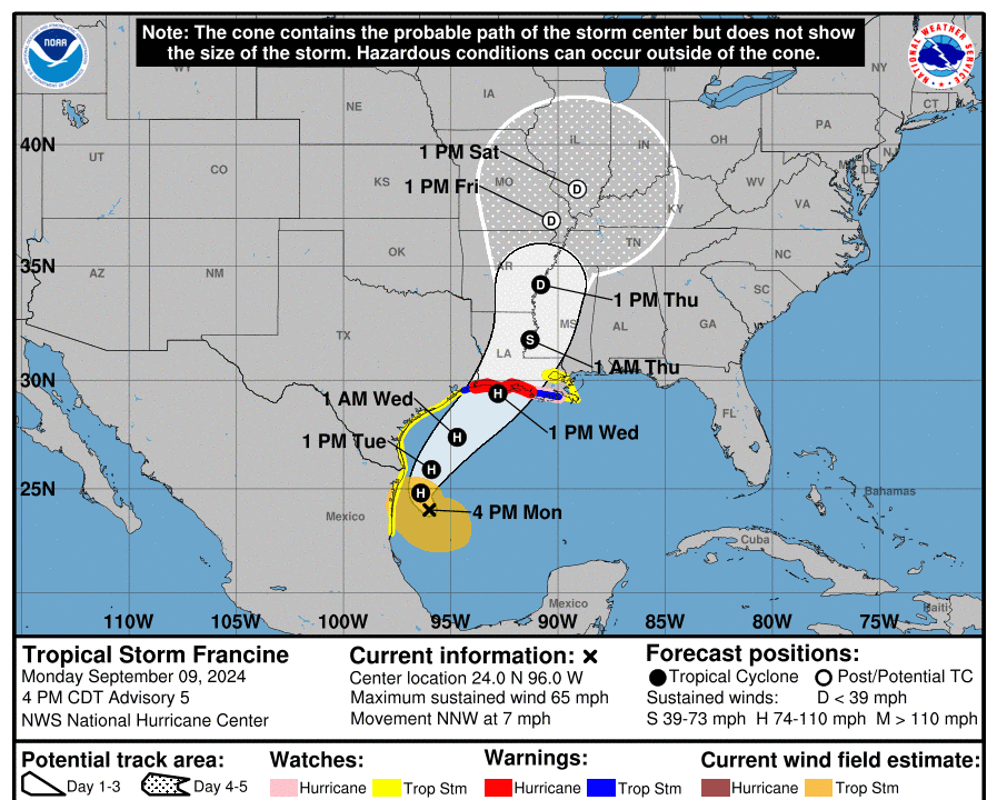
The forecast track has the eye making landfall in the Rockefeller Wildlife Refuge and then trekking inland north-northeast toward the Mississippi River, coming extremely close to cities including Lafayette, Lake Carles, Cameron, and Alexandria. It is expected to weaken into a tropical storm with 50-mile-per-hour winds within 12 hours of making landfall.

In anticipation of the storm’s arrival, Louisiana Gov. Jeff Landry issued a statewide emergency declaration and told members of the press on Sept. 9 that he had already spoken with FEMA Administrator Deanne Criswell and requested a pre-landfall presidential declaration.

He said the Emergency Operations Center’s Crisis Action Team had been activated, and the Governor’s Office of Homeland Security and Emergency Preparedness (GOHSEP) will go into a 24-hour emergency response mode on Sept. 10.

“We don’t want to downplay this event, but we also do not want people in the panic,” Landry said.

According to the NHC, the hurricane warning extends from Sabine Pass, around the Texas border, to Morgan City.

Tropical storm warnings extend out from the Hurricane warning zone from Sabine Pass to High Island, Texas, and from Morgan City to Grand Isle.

Metropolitan New Orleans and the entire Texas coastline from Port Mansfield to High Island are under a Tropical Storm Watch.

Storm Surge warnings now cover the Gulf Coast from east of High Island, Texas, to the mouth of the Mississippi River, including Vermilion Bay.

Francine was last spotted 150 miles south-southeast of the mouth of the Rio Grande. Maximum sustained winds have increased to 65 miles per hour, and tropical storm-force winds (39 miles per hour or greater) extend 160 miles out from the center.

A hurricane watch remains in effect from Morgan City to Grand Isle.

A tropical storm watch remains in effect for areas near the coastline, including Lake Pontchartrain, Lake Maurepas, and the area east of Grand Isle to the mouth of the Pearl River near Mississippi.

A tropical storm watch continues for the area surrounding the Rio Grande from Barra del Tordo, Mexico, to Port Mansfield, Texas.

While the storm is expected to remain offshore there, a meteorologist at the National Weather Service office in Brownsville, Texas, confirmed that the area received nearly three inches of rain between 12 a.m. and 9:45 a.m. on Sept. 9.

A storm surge watch is also in effect for the coast from High Island, Texas, to the Alabama–Mississippi border.

The NHC is predicting a five- to 10-foot storm surge between Cameron, Louisiana, and Port Fourchon, Louisiana. From there to the mouth of the Mississippi River, four to seven feet of surge is expected.

The coastline to the east, including Lake Pontchartrain and Lake Maurepas, is expected to experience a two- to four-foot surge.

Three to five feet of storm surge is expected from Cameron, Louisiana, to High Island, Texas, and even one to three feet is anticipated for the Texas Gulf Coast from Galveston Bay to the mouth of the Rio Grande.

The NHC noted that the waters are not expected to threaten levees, but there may be some flooding.

The center says the deepest water will be along the immediate coast, and the surge will be accompanied by “large and dangerous waves.”

The National Hurricane Center’s projected storm surge from Tropical Storm Francine as of 4 p.m. CDT on Sept. 9, 2024. (National Hurricane Center/National Weather Service)
The National Hurricane Center’s projected storm surge from Tropical Storm Francine as of 4 p.m. CDT on Sept. 9, 2024. National Hurricane Center/National Weather Service

In terms of rainfall, the NHC stated that Francine is expected to deliver four to eight inches of rain, with localized amounts of up to 12 inches “from the coast of far northeast Mexico northward along portions of the southern Texas coast, the far upper Texas coast and across southern Louisiana and southern Mississippi” through Sept. 12.

Texas Gov. Greg Abbott directed the Texas Division of Emergency Management on Sept. 8 to “activate additional state emergency response resources” ahead of the storm.

Emergency resources are on standby, including swift water rescue boat squads from the Texas A&M Engineering Extension Service; a tactical marine unit; highway patrol troopers; helicopters with hoist capabilities from the Department of Public Safety; and the Texas Emergency Medical Task Force.

Personnel from the Department of Transportation are ready to monitor road conditions.

“Texas stands ready to provide all available resources needed to support Texans as a severe storm system begins to move along the Gulf Coast that will bring potential flash flooding threats and heavy rain,” Abbott said in a statement.

“Texans are urged to take the necessary precautions for potential tropical weather, including remaining weather aware, monitoring road conditions, and having an emergency plan to ensure the safety of themselves and their loved ones.”

Louisiana is also beginning preparations.

GOHSEP launched a new version of its “Get a Game Plan” mobile app on Sept. 3.

“Stay alert and be prepared,” Gov. Jeff Landry wrote on X, formerly known as Twitter, on Sept. 8. ”Remember to GetAGamePlan.org for essential safety tips and strategies.”

GOHSEP Director Jacques Thibodeaux said, “Families often stay safer and suffer less loss when prepared for an ... emergency.”

Thibodeaux said the new version of the app “helps with the overall preparedness process.”

“We encourage everyone to download the app, provide the information, and use the results from the formula to help with planning,” he said.

Landry urged people to download the app during his Sept. 9 press conference. He will hold another press briefing at 11:30 a.m. Sept. 10.

If Francine develops into a hurricane, it will be the second one this season to hit the Texas and Louisiana Gulf Coast, after Hurricane Beryl.

T.J. Muscaro
T.J. Muscaro
Author
Born and raised in Tampa, Florida, T.J. Muscaro covers the Sunshine State, America's space industry, the theme park industry, and family-related issues.