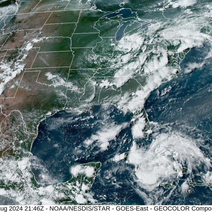
Tropical Storm Debby has appeared in the Gulf of Mexico and is now expected to make landfall as a hurricane in the “Big Bend” area of the Florida Panhandle, according to the National Hurricane Center.
Voluntary evacuation orders have been issued for Taylor, Union, Hernando, and Pasco Counties.
A hurricane warning is now in effect between the Suwannee River and Ochlockonee River, as well as for the stretch from Yankeetown to the Aucilla River. It is slightly southeast of Tallahassee and includes Cedar Key, Horseshoe Beach, Perry, and Keaton Beach.

West of Ochlockonee River to Indian Pass, and east of Suwannee River to Yankeetown, a tropical storm warning is now in effect. A tropical storm watch was added for the stretch of coast west of Indian Pass to Mexico Beach.
The NHC’s forecasted track shows the “cone of uncertainty” a fair distance from the west coast, but that does not mean residents in those areas are out of harm’s way.
Tropical storm-force winds (winds 39 mph - 73 mph) extend 140 miles out from the storm’s center.
Satellite and radar imagery show the storm’s outer bands already beginning to deliver heavy rain and harsh winds on the southern half of the Florida Peninsula. Waterspouts have been detected off the coast.
Major flooding events from storm surges and rainfall are expected across the state as well, triggering the evacuations of coastal and low-lying areas.
Storm surge warnings and watches continue to spread across the Gulf Coast, with four to seven feet of extra water above the high tide line expected in the Big Bend area between Yankeetown and the Aucilla River.
Stretching out from Yankeetown to Aripeka, and from the Aucilla River to Indian Pass, three to five feet of storm surge is expected.
Storm surge of two to four feet is expected in Tampa Bay, Charlotte Harbor, and the stretch of coastline between Bonita Beach and Aripeka.
Reading rainfall, the NHC states “Tropical Storm Debby is expected to produce rainfall totals of six to 12 inches, with maximum rainfall totals up to 18 inches, across portions of Florida and along the southeast US coast this weekend through Thursday.
“This rainfall will likely result in areas of considerable flash and urban flooding, with significant river flooding expected.”

Guthrie also took the opportunity to advise Floridians to heed the evacuation warnings, emphasizing that this storm could still get bigger.
“We could be looking again at a strong Category One hurricane,” he said. “And again, there’s nothing in its way, right? When we say, ‘nothing’s in its way,’ [we mean] there is no wind shear. There is nothing there that would prevent it from coming together very quickly, and we’ve seen what storms can do in the Gulf of Mexico.
“Hurricane Michael went from a tropical storm to a Category Five hurricane in about 36 hours. So, [I’m] not saying it’s going to become a Category Five, but there is nothing that would prevent it from rapidly intensifying.”
Florida Gov. Ron DeSantis declared a state of emergency for more than 50 counties on Aug. 1 and extended the order on Aug. 2 to include seven more counties. Those counties include every one located on the Gulf Coast and the Panhandle.
The governor’s office announced several storm preparation updates on Aug. 2, jumpstarting proactive measures from a variety of disciplines from law enforcement to healthcare.
Approximately 3,000 Florida National Guard Members are readying for response efforts, and the Florida State Guard activated 70 members for response and recovery support, nine shallow water vessels, 10 UTVs, two amphibious rescue vehicles, and seven search-and-rescue crews.
“It gives the governor the ability to spend money,” Guthrie said of the emergency declaration. “It gives counties the ability to spend money instead of going through a very bureaucratic process for procurements and things of that nature. It allows us to spend money, and enter into contracts, and enter into purchase orders much more quickly.
“It also allows us to, then, bring in people that are not typically day-to-day full-time state employees.”
He cited the National Guard and Florida State Guards as examples.
The Florida Department of Health is staging 90 ambulances to support emergency evacuations throughout the state.
The Florida Department of Transportation is working with the Emergency Operations Center to make preparations. Those preparations include analyzing flood vulnerabilities, securing construction sites, and replenishing fuel reserves.
Attorney General Ashley Moody’s office activating the Florida price gouging hotline.
FDEM activated the State Emergency Operation Center to level one and is now leading coordination efforts.