Tens of millions of Americans are currently under freeze warnings or watches on Tuesday, according to federal forecasters.
A map posted by the National Weather Service (NWS) shows that freeze warnings and watches were mainly issued across the U.S. southeast and mid-Atlantic states. It noted that lake-effect snow may impact areas around the Great Lakes, which will make for hazardous conditions in areas where several inches fall.
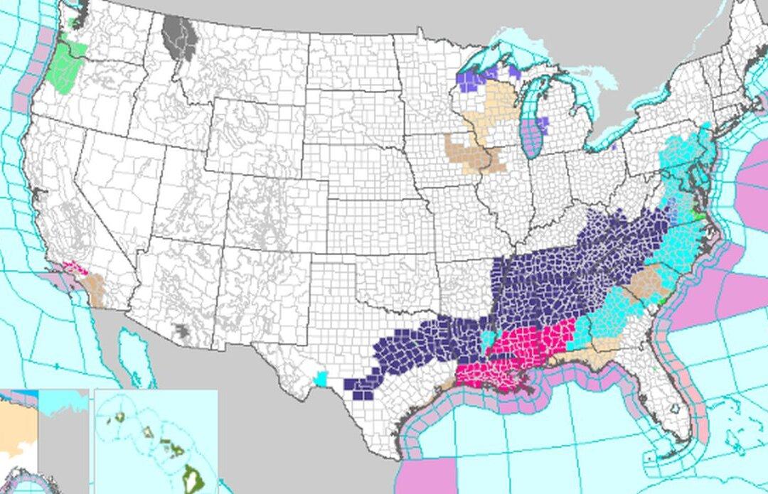
“As colder air slides east and south, frost and freeze conditions with new record low temperatures are expected through the middle of the week,” the agency says.
High temperatures on Tuesday “are expected to range from 10 to 30 degrees below average everywhere east of the Rockies,” it adds. “This equates to Halloween afternoon temperatures only reaching the 40s and 50s for most, with 30s in the Midwest, Great Lakes, central and northern Plains,” the NWS bulletin said, adding that “ temperatures will be chillingly cold while dipping into the teens and 20s for most locations” at night.
“Many areas will end their growing season over the next few days from the southern Plains to the Mid-Atlantic, including parts of the Deep South. Exposed water pipes will also be at risk of freezing or bursting if proper precautions are not taken,” it said. “Freeze warnings and watches as well as frost advisories are in effect. The cold and dry airmass when combined with gusty winds may also increase fire weather danger across the central Gulf Coast states, prompting Red Flag Warnings to be issued.”
Some snow has already fallen from Colorado to South Dakota over the past several days, with some areas getting up to 19 inches of snow, according to the NWS. Denver International Airport received around 7.5 inches of snow over the past weekend, while some areas near Denver saw 10 to 11 inches Sunday.
Broader Forecasts
The storm warnings were issued this week after the National Oceanic and Atmospheric Administration (NOAA) recently released its winter outlook that predicted warmer temperatures in the northern United States and wetter conditions in the south.“This year, El Niño is in place heading into winter for the first time in four years, driving the outlook for warmer-than-average temperatures for the northern tier of the continental United States,” the NOAA said.
Between December and February, “wetter-than-average conditions” are forecast for northern Alaska, some western states, southern Plains states, the Southeast, Gulf states, and the lower mid-Atlantic states, according to NOAA’s forecast.
At the same time, it predicted “drier-than-average conditions across the northern tier of the U.S., especially in the northern Rockies and High Plains and near the Great Lakes.”
In contrast, the Old Farmer’s Almanac forecast that “snowfall will be above normal across most snow-prone areas” other than the Pacific Northwest. Temperatures across the United States will see “normal to colder-than-normal temperatures in areas that typically receive snow,” and only New England and the Atlantic Corridor will enjoy winter temperatures milder than typical for their regions.”
A few of the cities that historically experienced the first snow of the season in November include Boston (Nov. 29), Chicago (Nov. 18), Cleveland (Nov. 10), Pittsburgh (Nov. 17), and Salt Lake City (Nov. 8).