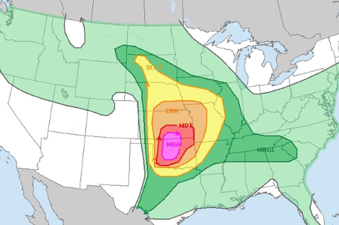
Millions of people in the central United States are bracing for strong storms this week, including large tornadoes and strong winds that could hit multiple areas on the evening of May 6.
Much of Oklahoma and parts of Kansas are at the greatest risk for bad weather. This includes Sulphur and Holdenville, Oklahoma on May 6, the National Weather Service (NWS) warned. Both the Plains and Midwest have been hammered by tornadoes this spring.
For Monday, nearly 10 million people live in areas under threat of severe weather, the National Weather Service’s Storm Prediction Center said, issuing a rare high risk for central Oklahoma and southern Kansas.
Other cities that could see stormy weather on May 6 include Kansas City, Missouri, as well as Lincoln, Nebraska, the NWS map shows.
“The thing to remember is if you see a storm near you, assume it’s a dangerous storm,” it wrote, adding, “We have not experienced a day like this in quite some time.”
“The potential for tornadoes will INCREASE after dark, so do not let your guard down,” the post continued, saying the chance of tornado formation becomes “favorable after dark.”
In “many locations” one “won’t see a storm, but if you do, it will be bad ... please check the weather before you get in your vehicle this afternoon to leave work or school. If there are storms nearby, consider delaying your trip!”
Meanwhile, Bill Bunting, deputy director of the Storm Prediction Center, said a high risk from the center is not something seen every day or even every spring.
“It’s the highest level of threat we can assign. And it’s a day to take very, very seriously,” he said.
Mr. Bunting urged people in the affected areas to develop a severe weather plan early in the day.
“Make sure that you have ways to communicate with your family members,” he stated. “Make sure everyone knows where their shelters are,” and how they can continue to receive warnings.
Meanwhile, early Monday heavy rains hit southwestern Texas, especially the Houston area, leaving neighborhoods flooded and leading to hundreds of high-water rescues.
The entire week is looking stormy across the U.S. The eastern U.S. and the South are expected to get the brunt of the bad weather through the rest of the week, including in Indianapolis, Memphis, Nashville, St. Louis, and Cincinnati, where tens of millions of people live.
“A few tornadoes, large to very large hail, and severe/damaging winds all appear possible, particularly from northeast Indiana into northwest and central Ohio.”
“A volatile setup from severe thunderstorms has become more apparent from northeast Texas into the Mid-South/mid MS Valley and parts of the OH Valley, where an Enhanced Risk has been introduced,” the NWS said for the May 7 outlook.
“Current expectations are for severe convection to erupt fairly early in the day, perhaps by late Wednesday morning, along both the cold front and warm front as ascent with the shortwave trough overspreads the rapidly destabilizing warm sector.”