Summer 2024: Much of US Could Be in for Record-Breaking Temperatures, Forecasters Say

Summer 2024 could see extended periods of warmer-than-average conditions, according to NOAA.
Summer 2024: Much of US Could Be in for Record-Breaking Temperatures, Forecasters Say
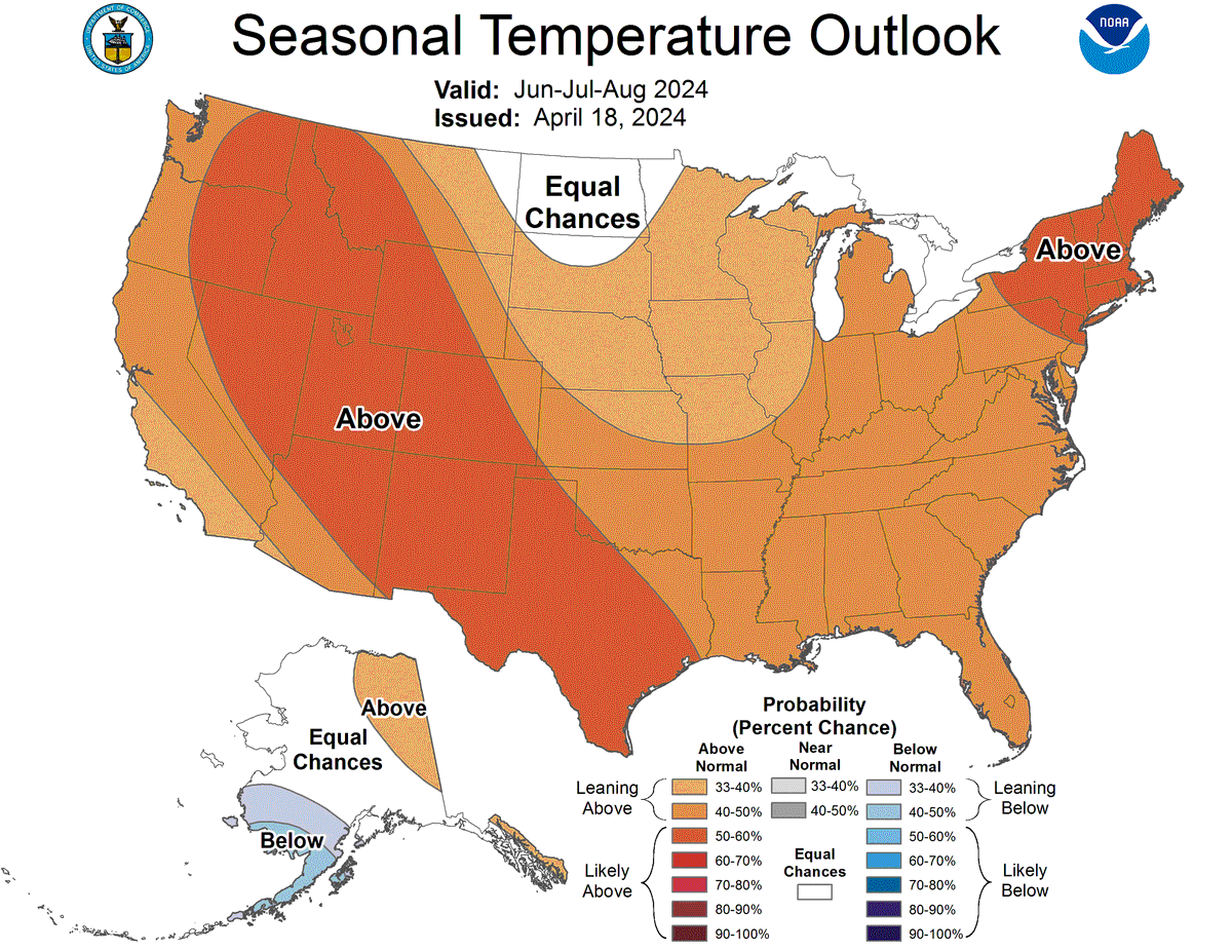
The summer forecast map, issued on April 18, 2024, shows that almost the entire nation is expected to see above-average temperatures, shown in orange and red. Courtesy of NOAA
Updated:
0:00

An unusually hot summer has been predicted for most of the United States this year, according to weather forecasters. Warmer-than-average temperatures are expected from June through August. A summer forecast map released by the National Oceanic and Atmospheric Administration (NOAA) on April 18 shows most of the United States bathed in shades of red or orange.

According to NOAA, the Northeast and major parts of the West will likely bear the brunt of the heatwave, which, according to some forecasters, could be one of the hottest summers on record.
Previous record-breaking temperatures were recorded in 1936 and most recently in 2021. According to Todd Crawford, a forecaster with the Weather Company, these could be matched or even exceeded this year.

The Weather Company echoed NOAA’s forecasts by announcing that much of summer 2024 could see extended periods of warmer-than-average conditions.

However, not all forecasters share the optimism for a hot summer. According to AccuWeather, temperatures are not looking as promising as those forecasted by other weather service agencies.

AccuWeather, which is set to release its summer forecast on May 1, has predicted a milder-than-average summer across much of the United States, with occasional hot spots scattered throughout the Northeast and Southwest, USA Today reported.

NOAA meteorologist Anthony Artusa outlined additional factors that could potentially play a role in elevated temperatures this summer. Mr Artusa referred to the waning El Niño, in addition to the developing La Niña as the main contributing factors for a warmer-than-average summer.

Included in this are long-term trends of above-normal temperatures, which according to Mr Artusa, holds true especially for northeastern parts of the United States.

The El Niño and La Niña are natural weather phenomena, categorized by their warming of sea surface temperatures that occurs every few years, typically concentrated in the central-east equatorial Pacific.

El Niño represents the warmer-than-average aspect, while La Niña represents the cooler cycle, according to the Met Office.

“These episodes alternate in an irregular inter-annual cycle called the ENSO cycle. ‘ENSO’ stands for ‘El Niño Southern Oscillation’, where ‘Southern Oscillation’ is the term for atmospheric pressure changes between the east and west tropical Pacific that accompany both El Niño and La Niña episodes in the ocean.”

Both phenomena can also play a role in tropical storm developments in the North Atlantic.

Meanwhile, those who would prefer cooler-than-average temperatures for the summer may be disappointed, except for those living in the far northern Plains, which could potentially experience lower temperatures.

While a soggy summer could still occur along much of the Eastern Seaboard, the Plains and the Rockies can expect a drier-than-average summer. This, combined with the heat, could increase the risk of wildfires and drought across the western parts, according to Mr. Artusa.

From NTD News