Unprecedented Tropical Storm Watch Issued for California as Cat 4 Storm Looms

Hurricane Hilary grew rapidly to Category 4 strength off Mexico’s Pacific coast on Friday and could reach Southern California as a tropical storm
Unprecedented Tropical Storm Watch Issued for California as Cat 4 Storm Looms
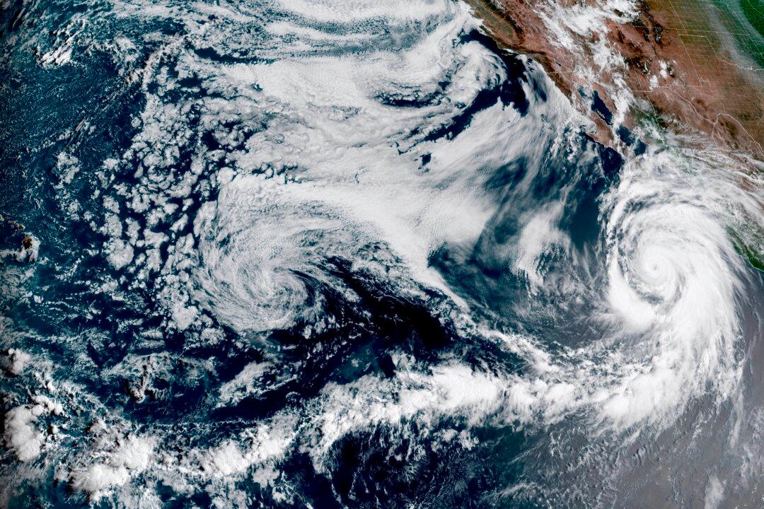
A satellite image shows Hurricane Hilary off Mexico’s Pacific coast at 1:10 p.m. ET on Aug. 18, 2023. NOAA via AP
Jack Phillips
Updated:
0:00

Hurricane Hilary grew rapidly to Category 4 strength off Mexico’s Pacific coast on Friday and could reach Southern California as a tropical storm, according to forecast maps.

The U.S. National Hurricane Center (NHC) said Hilary had sustained winds near 145 mph as of Friday morning and was expected to continue its rapid intensification through Friday before starting to weaken. It will nevertheless still be a hurricane when it approaches Mexico’s Baja California peninsula on Saturday night, and will approach Southern California on Sunday as a tropical storm.
A tropical storm watch was issued for Southern California on Friday afternoon, according to the NHC. Analysts say it’s the first time a tropical storm watch has ever been issued for the region.

A forecast model from the NHC shows that Hilary will remain a tropical storm when it reaches Southern California at around 12 a.m. on Monday local time. No tropical storm has made landfall in Southern California since Sept. 25, 1939, according to the National Weather Service.

That model also shows that the storm will remain a tropical depression until 12 a.m. Tuesday when it approaches the border between Idaho and Oregon more than 1,000 miles to the north.

“Heavy rainfall associated with Hilary may produce areas of flash flooding and result in landslides over portions of the Baja California Peninsula from late today into late Sunday. Rainfall impacts from Hilary within the Southwestern United States are expected to peak this weekend into Monday,” said the NWS’s forecast discussion. “Flash, urban, and arroyo flooding is expected with the potential for significant impacts.”

Early Friday, Hilary was centered around 400 miles south of Los Cabos on the southern tip of the Baja peninsula. It was moving west-northwest at 13 mph, but was expected to turn gradually north through Saturday.

The Mexican government extended its hurricane watch and tropical storm warning northward for parts of the state of Baja California Sur, and also issued a tropical storm watch for parts of mainland Mexico.

When it impacts Southern California, the storm is forecast to produce heavy rainfall. Flash flooding will likely impact some of the driest portions of California.

“Rainfall amounts of 3 to 6 inches, with isolated amounts of 10 inches, are expected across portions of southern California and southern Nevada, which would lead to significant and rare impacts. Elsewhere across portions of the Western United States, rainfall totals of 1 to 3 inches are expected,” the National Hurricane Center said.

In Southern California, an outlook for excessive rainfall stretched from Sunday to Tuesday, according to the Los Angeles weather office. The Mexican government said a weakened Hilary might hit the coast Sunday night between the cities of Playas de Rosarito and Ensenada, in Baja California state.

Meanwhile, the city of Yuma was preparing Thursday by providing residents with a self-serve sandbag filling station. The sandbag station will be stocked with sand and empty bags for self-filling while supplies last. Residents were allowed five sandbags per vehicle.

Local reports indicated that the City of San Diego has established an Emergency Operations Center before Hilary makes landfall. San Diego County is also offering residents sandbags.

The storm is forecast to significantly weaken as it approaches California, AccuWeather meteorologist Scott Homan said. “However the impacts of the storm will be well ahead of that as lots of moisture gets strung northward into the storm system and then moves north into California,” Homan told USA Today.

‘Above-Normal’ Season

Amid the current lull in the Atlantic hurricane season, the National Oceanic and Atmospheric Administration’s (NOAA) Climate Prediction Center raised its 2023 prediction for the 2023 season from near-normal to “above-normal.”
“Considering those factors, the updated outlook calls for more activity, so we urge everyone to prepare now for the continuing season,” Matthew Rosencrans, lead hurricane season forecaster with NOAA center, said in an Aug. 10 statement.
According to the NHC’s hurricane map, there are currently no tropical storms, depressions, or hurricanes in the Atlantic basin. There are four disturbances currently in the basin, although two of them have a zero and 10 percent chance of formation, respectively, while the other two have a 40 percent and 60 percent respective chance of formation in the next 48 hours.

NOAA said that for 2023, there will be 14 to 21 named storms, of which six to 11 will become at least Category 1 hurricanes. Of that, two to five will become major hurricanes.

The 2023 season ends on Nov. 30, while peak storm activity is generally in early September. So far, there have been five tropical storms and Hurricane Don, which dissipated in the North Atlantic Ocean.

The Associated Press contributed to this report.
Jack Phillips
Jack Phillips
Breaking News Reporter
Jack Phillips is a breaking news reporter who covers a range of topics, including politics, U.S., and health news. A father of two, Jack grew up in California's Central Valley. Follow him on X: https://twitter.com/jackphillips5
twitter
Related Topics