Louisiana Residents Evacuate, Make Final Preparations for Hurricane Francine

The storm has intensified to hurricane status. Storm surge warnings are in effect from High Island, Texas, to the Mississippi-Alabama border.
Louisiana Residents Evacuate, Make Final Preparations for Hurricane Francine
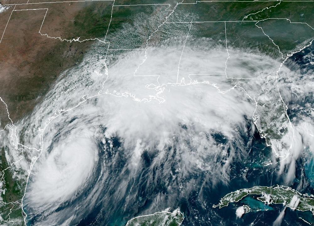
Satellite image of Tropical Storm Francine in the Gulf of Mexico as of 3:36 p.m. ET on Sept. 10, 2024. NOAA/NESDIS/STAR - GOES
T.J. Muscaro
Updated:
0:00

Mandatory evacuations are underway as Louisiana prepares for the arrival of Hurricane Francine by Wednesday evening.

The storm reached hurricane status on Tuesday, the National Hurricane Center (NHC) stated in a 7 p.m. CT advisory update that same day.

“All of south-central and southeastern Louisiana [are] under the gun with this storm,” meteorologist Jay Grymes said during an earlier press briefing that day.

Residents still had the rest of the day to prepare, he said, but landfall was expected around mid-afternoon or early evening on Wednesday, and tropical storm or hurricane-force conditions are going to be felt all across the I-10 and I-12 corridor.

The NHC said in its 7 p.m. CT advisory that the storm’s maximum sustained winds have increased to near 75 mph with higher gusts. Additional strengthening is expected through to Wednesday morning before weakening quickly after the storm moves inland.

Hurricane-force winds will extend outward up to 30 miles east of the center, and tropical-storm-force winds will extend outward up to 140 miles from the center, according to the NHC.

The forecasted track continues to shift eastward, and landfall is projected to be east of Vermilion Bay. A meteorologist at the National Weather Service’s Lake Charles office told The Epoch Times that the storm could come close to the Baton Rouge area.

Francine is expected to be a strong Category One hurricane upon landfall, with maximum sustained winds reaching 90 mph.

Some level of storm surge caused by Francine is expected along the Gulf Coast from the Mouth of the Rio Grande (one to three feet) to the Alabama-Florida border (two to four feet).

Five to 10 feet is expected along the Louisiana coastline between the Rockefeller Wildlife Refuge and Port Fourchon, including Vermilion Bay. Four to seven feet is expected eastward from Port Fourchon to the mouth of the Mississippi River.

Heavy rainfall in the amount of four to eight inches, with isolated areas of 12 inches, is still expected, and along with it, the risk of flash and urban flooding.

Hurricane warnings extend from Sabine Pass to the east of Grand Isle. Tropical storm warnings extend further along the coast to the Mississippi border and inland to include New Orleans and Lake Pontchartrain. Tropical Storm watches are in effect from Mississippi to the Alabama-Florida border.

The National Hurricane Center’s projected storm surge from Tropical Storm Francine as of 10 a.m. CT on Sept. 10, 2024. (National Hurricane Center/National Weather Service)
The National Hurricane Center’s projected storm surge from Tropical Storm Francine as of 10 a.m. CT on Sept. 10, 2024. National Hurricane Center/National Weather Service

Several parishes in Louisiana have already issued mandatory or voluntary evacuation orders for residents in vulnerable areas.

Jefferson Parish President Cynthia Lee Sheng, for instance, issued a mandatory evacuation order on Monday for residents living “outside of the levee protection system” in anticipation of the life-threatening storm surge. This includes Grand Isle.
Iberia Parish President M. Larry Richard urged residents living south of U.S. Highway 90 to consider evacuating. Part of Iberia Parish sits on Vermilion Bay.
Cameron Parish Office of Homeland Security and Emergency Preparedness also issued a mandatory evacuation for the southern portion of its area. This went into effect at 6 a.m. on Tuesday. The evacuated area includes Hackberry, Johnson Bayou, Holly Beach, Cameron, Creole, Grand Chenier, and Big Lake.
Evacuations are also underway in Texas. Galveston County Judge Mark Henry signed a voluntary evacuation order on Tuesday for the Bolivar Peninsula in anticipation of the storm surge.

All watches and warnings for the Texas coast between the mouth of the Rio Grande and Matagorda have been lifted.

Louisiana’s Gov. Jeff Landry has activated emergency response resources. The Governor’s Office of Homeland Security and Emergency Preparedness went into a 24-hour emergency response mode on Tuesday, and thousands of linemen have been pre-staged to restore power.

Adjunct General of Louisiana, Maj. Gen. Thomas C. Friloux told reporters that National Guardsmen were being deployed across Louisiana with 87 boats, 387 high-water vehicles, and more than 50 helicopters at their disposal. Search and rescue, he said, was the most likely post-storm mission they would have to undertake.

The National Guard is also packing emergency resources, including more than one million meals and 1.1 million gallons of water.

Landry also sent a letter on Tuesday to President Joe Biden requesting a presidential emergency declaration.
“After declaring a State of Emergency, we have now determined that this storm is of such severity that an effective response is beyond the capabilities of the state and local governments,” he said in a statement. “This federal assistance is needed to save lives and property, and I look forward to President Biden quickly approving this request.”
This report was updated following the NHC’s 7 p.m. CT advisory.
T.J. Muscaro
T.J. Muscaro
Author
Born and raised in Tampa, Florida, T.J. Muscaro covers the Sunshine State, America's space industry, the theme park industry, and family-related issues.