Hilary Becomes a Major Hurricane, May Bring ‘Significant Impacts’ to US Southwest

Tropical Storm Hilary became a hurricane early Thursday morning as forecasters warned it could intensify and bring rare impacts into Southern California.
Hilary Becomes a Major Hurricane, May Bring ‘Significant Impacts’ to US Southwest
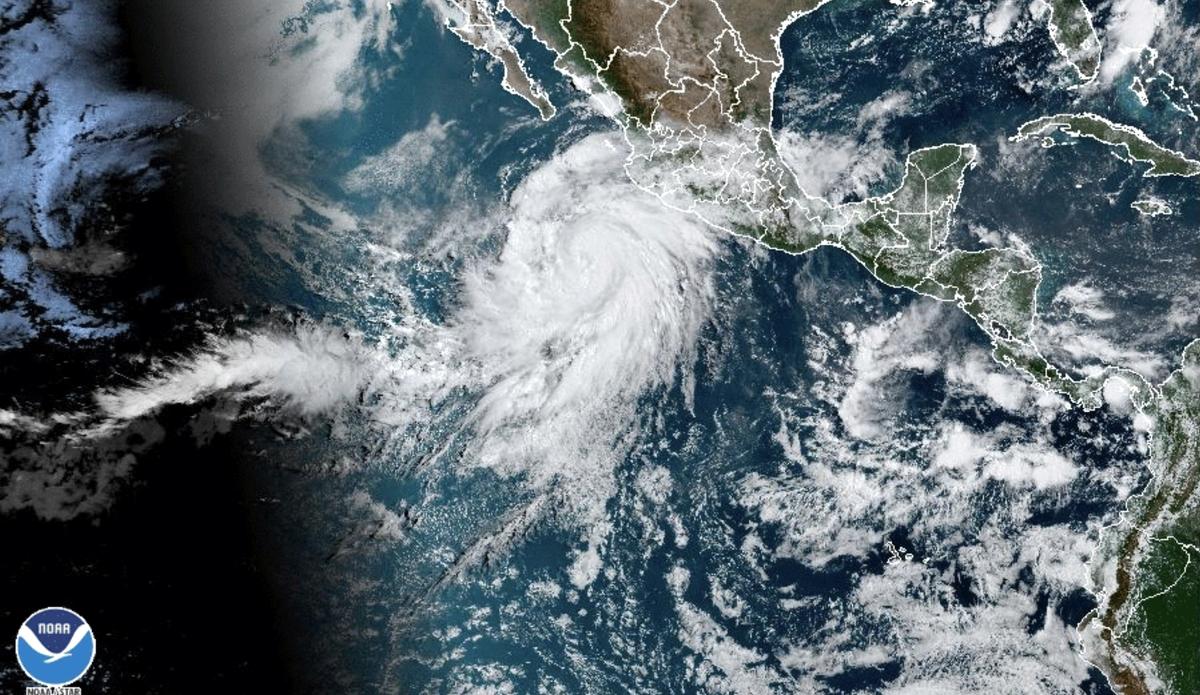
A satellite image shows Hurricane Hilary off the Pacific coast of Mexico at 10:50 a.m. ET on Aug. 17, 2023. NOAA via AP
Jack Phillips
Updated:
0:00

A tropical storm, Hilary, became a hurricane early on Aug. 17 off Mexico’s Pacific coast, and later rapidly strengthened into a major hurricane, as forecasters warned that it has the potential to bring devastating rainfall and high winds to Southern California and the southwestern United States by the end of the week.

“Hilary has the potential to bring significant impacts to the Baja California Peninsula and portions of the southwestern United States this weekend and early next week,” the National Hurricane Center (NHC) said in an advisory.
“Heavy rainfall associated with Hilary may produce areas of flash flooding and result in landslides over portions of the Baja California Peninsula from late Friday into late Sunday,” the NHC said in a separate forecast discussion.

“Rainfall impacts from Hilary within the Southwestern United States are expected to peak this weekend into Monday. Flash, urban, and arroyo flooding is possible with the potential for significant impacts.”

Hurricane Hilary is forecast to intensify this week into a Category 4 hurricane with 130-mile-per-hour winds. The storm is expected to weaken significantly before it reaches Southern California.

As of 8:00 p.m. ET Aug. 17, Hurricane Hilary reached maximum sustained winds of 120 miles per hour (195 kilometers per hour), which makes it a Category 3 hurricane, or a major hurricane, on the Saffir-Simpson Hurricane Wind Scale. It was located about 445 miles (715 kilometers) south of Cabo San Lucas, Mexico.

It marked a rapid progression from Category 2 sustained winds noted earlier in the afternoon, at 110 miles per hour (175 kilometers per hour).

Hilary is forecast to approach the Baja Peninsula of California on Aug. 19.

A forecast model shows that the storm may weaken to a tropical storm by the time it hits Southern California early on Aug. 21. The storm then may ease to a tropical depression by early on Aug. 22.
Portions of the Inland Empire metropolitan area could see as much as six inches of rain, while much of Southern California, including San Diego and Los Angeles, could get 1 to 4 inches. Parts of the Sierra Nevada mountains and areas near Las Vegas could also receive as much as six inches of rain, according to the National Weather Service (NWS).
“Hilary has the potential to bring significant impacts to the Baja California Peninsula and portions of the southwestern United States this weekend and early next week, including after it becomes post-tropical,” the NHC said in a forecast discussion. “Although it is too soon to determine the location and magnitude of wind impacts, interests in these areas should monitor the progress of Hilary and updates to the forecast. A Tropical Storm Watch is now in effect for southern portions of Baja California Sur, and additional watches or warnings will likely be required later today.”

It also noted that heavy rainfall could result in flash flooding and landslides on the Baja California peninsula from [Aug. 18] to [Aug. 20].

“Rainfall impacts from Hilary within the Southwestern United States are expected to peak on Sunday and Monday,” it added.

Daniel Swain, a scientist at the University of California–Los Angeles, told CNN on Aug. 16 that “multiple years’ worth of precipitation” could fall in Southern California.

“This does have the potential to be a very high impact event for portions of Southern California,” the NWS’s San Diego office stated. “There is still a degree of uncertainty in the forecast and more details will come on exact timing, location, and magnitude of impacts in the coming days.”

‘Above-Normal’ Season

Amid the current lull in the Atlantic hurricane season, the National Oceanic and Atmospheric Administration’s (NOAA) Climate Prediction Center raised its 2023 prediction for the 2023 season from near-normal to “above-normal.”
“Considering those factors, the updated outlook calls for more activity, so we urge everyone to prepare now for the continuing season,” Matthew Rosencrans, lead hurricane season forecaster with NOAA center, said in an Aug. 10 statement.
According to the NHC’s hurricane map, there are currently no tropical storms, depressions, or hurricanes in the Atlantic basin. There are two disturbances with a 4o to 60 percent chance of forming a tropical cyclone within the coming two days, however.

“NOAA’s update to the 2023 outlook—which covers the entire six-month hurricane season that ends on Nov. 30—calls for 14-21 named storms (winds of 39 mph or greater), of which 6–11 could become hurricanes (winds of 74 mph or greater),” the statement reads. “Of those, 2–5 could become major hurricanes (winds of 111 mph or greater). NOAA provides these ranges with a 70 percent confidence. These updated ranges include storms that have already formed this season.”

So far, there have been five tropical storms and Hurricane Don, which dissipated in the North Atlantic Ocean.

Jack Phillips
Jack Phillips
Breaking News Reporter
Jack Phillips is a breaking news reporter who covers a range of topics, including politics, U.S., and health news. A father of two, Jack grew up in California's Central Valley. Follow him on X: https://twitter.com/jackphillips5
twitter
Related Topics