Hurricane Helene, a Category 4 storm, is projected to slam Florida’s northwestern coast on the evening of Sept. 26. It is also forecast to bring heavy rains across much of the southern United States over the coming weekend.
A map from the National Hurricane Center (NHC) on Sept. 26 shows Hurricane Helene hitting the Florida Panhandle, with the state’s capital Tallahassee being at or near the center of the storm’s forecasted path. The storm is expected to strengthen further before making landfall, according to the NHC.
The National Weather Service (NWS) warned on social media that a “catastrophic and deadly storm surge is likely along portions of the Florida Big Bend coast, where inundation could reach as high as 20 feet above ground level, along with destructive waves.”
Multiple Impacts in Several States
Federal Emergency Management Agency Administrator Deanne Criswell warned that Hurricane Helene would impact regions from Florida to Tennessee.“This is going to be a multi-state event with the potential for significant impacts from Florida all the way to Tennessee,” Criswell said at a White House press briefing on Sept. 26.
Disaster declarations have been approved by the Biden administration in Florida, North Carolina, and Georgia, which are in the path of the storm system. Modeling from the NHC shows that Helene will weaken after hitting land, becoming a tropical storm somewhere over Georgia by the morning of Sept. 27 before being downgraded into a tropical depression.
“We expect life-threatening flash flooding” as the storm moves north, Criswell said, noting that people should listen to local officials for warnings.
Atlanta Gets Flash Flood Warning
More than 2 million people in Georgia, including the metropolitan Atlanta area, are under a flash flood warning as of the evening of Sept. 26, officials said.
Helene is expected to at least be a tropical storm when it reaches metro Atlanta.
Georgia Gov. Brian Kemp told a press conference on Sept. 26 that Georgia residents shouldn’t take the storm lightly.
“Helene is a massive storm, and we are expecting significant damage across the state,” he said. “I urge all residents to stay off the roads during and after the storm to help emergency crews clear debris and restore power.”
Asheville Area Could See Record Rain, Flooding
Record-breaking flooding is forecast in Asheville, North Carolina, the NWS’s local office said in an “urgent message” on Sept. 26 as it described the storm as “one of the most significant weather events” in the “modern era” for the city and state.
Seven inches of rain have already fallen in Asheville, while some other areas have seen even more. All of the water is flowing downhill out of the mountains.
“This next wave (of rain) is just going to be even worse because there’s nowhere for the water to be soaked up or go,” Asheville Fire Chief Michael Cayse told CNN on Sept. 26.
Heavy Rain Forecast Elsewhere
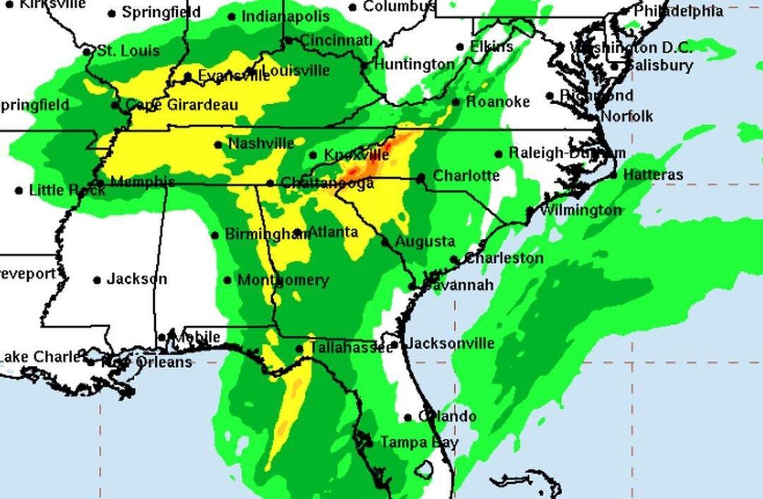
In western North Carolina and South Carolina, more than 12 inches of rain is expected in some areas, an NHC model shows. Parts of Florida, Virginia, Georgia, Alabama, Tennessee, Kentucky, Arkansas, Missouri, Indiana, and Illinois could see 4 to 6 inches of rain, it shows.
Specifically, over areas of the southern United States into the southern Appalachian Mountain region, Helene will produce 6 to 12 inches in rainfall with isolated amounts of 20 inches, the agency stated.
Agency forecasters warn that there is a moderate-to-high chance of flash flooding across much of the southern United States over the next three days.“This rainfall will likely result in catastrophic and potentially life-threatening flash and urban flooding, along with significant river flooding. Numerous significant landslides are expected in steep terrain across the southern Appalachians,” the NHC stated.
Flood Warnings in Mountains
Emergency officials in the North Carolina mountains are warning that heavy rains before Hurricane Helene even arrives have set the stage for historic flooding.The French Broad River and Swannanoa River, which run in and around Asheville and then south, are already predicted to break 100-year-old records from Sept. 27 into Sept. 28. The flooding could be worse than in 2004, when water rose to car rooftops in Biltmore Village just outside the gates of the historic Biltmore estate built by George Vanderbilt.
“This is a potentially historic event with catastrophic, deadly consequences. This is not a maybe. This is on track to happen. So please, please take every precaution to take yourself out of harm’s way,” Buncombe County Emergency Services Director Taylor Jones said.
Tornadoes Anticipated
There is a chance that “several tornadoes” may appear on the evening of Sept. 26 into the morning of Sept. 27 associated with Helene, the NWS wrote on X.The greatest threat can be anticipated in Florida, southeastern Georgia, the Midlands and Low Country regions of South Carolina, and the southern part of North Carolina, it warned.