Health Hazards Await as California’s Fire Evacuees Return Home

Dangers include tainted water, toxic debris, and the threat of landslides. Meanwhile, high winds make a comeback.
Health Hazards Await as California’s Fire Evacuees Return Home
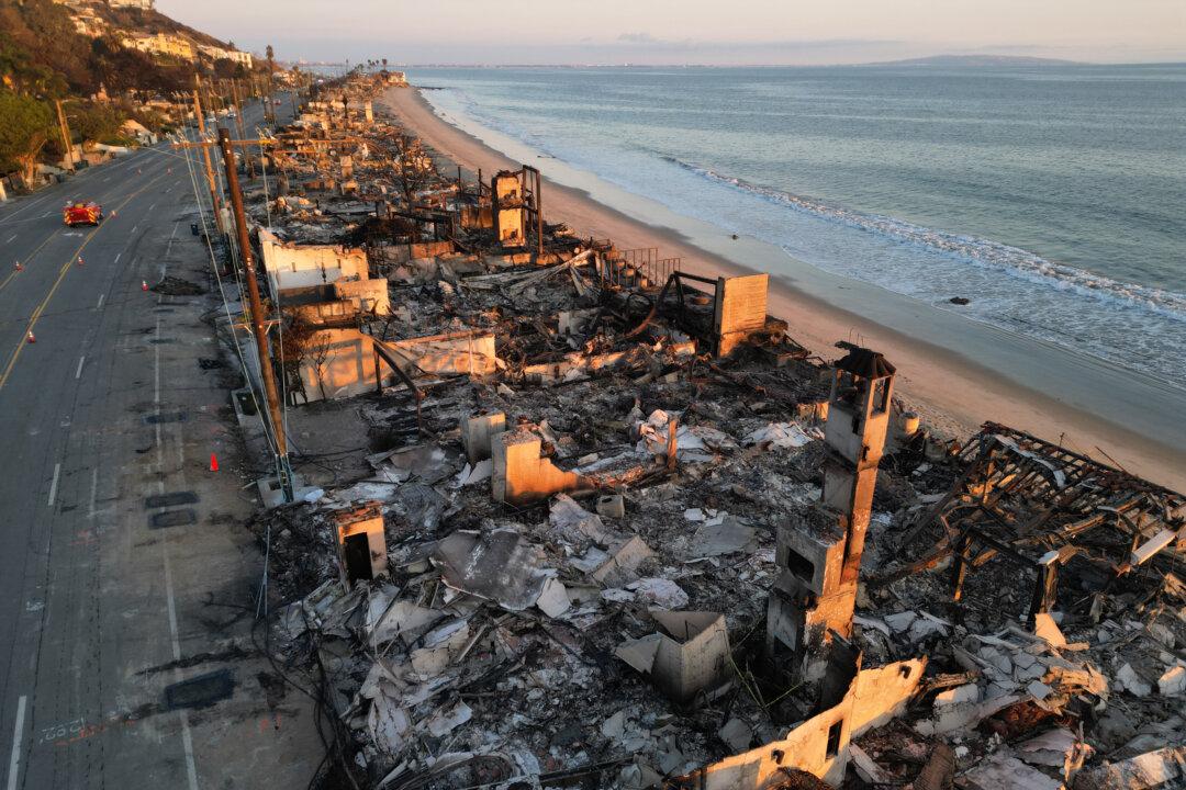
The remains of oceanfront homes destroyed by the Palisades Fire along Pacific Coast Highway in Malibu, Calif., on Jan. 17. Robyn Beck/AFP via Getty Images
Jill McLaughlin
Updated:
0:00

Officials on Jan. 20 allowed more Southern California residents to return home to neighborhoods destroyed or damaged by recent catastrophic wildfires, but many face hazards, including contaminated water, toxic debris, and landslides.

The two major wildfires, the Palisades and Eaton fires, that started on Jan. 7 are still burning. Fire crews have the upper hand on both this week despite the arrival of more Santa Ana winds and red-flag fire danger weather warnings, according to the California Department of Forestry and Fire Management (Cal Fire).
As residents begin to repopulate the areas, Los Angeles County has issued warnings about hazardous windblown dust and ash, as well as toxic debris.

On Jan. 19, the county’s health department issued a dust and ash advisory in anticipation of another round of strong Santa Ana winds expected to affect the area starting Jan. 21.

“Windblown dust and ash contain small particles that may cause irritation or exacerbate pre-existing health conditions, particularly for children, older adults, pregnant individuals, and those with heart or lung conditions,” the department wrote in a statement.

Health officials are encouraging the public to stay inside, keep windows and doors closed, wear masks, and protect their eyes.

The county health officer also issued an order on Jan. 15 warning the public about the debris and ash left by the fires, especially in the areas of the Palisades and Eaton fires and the fires near Sylmar, between Ventura and Los Angeles counties, and around Soledad Canyon Road, West Hills, and Big Tujunga Creek. The first two fires have burned a total of nearly 40,000 acres, or 63 square miles. Of the last four fires, the fire near West Hills is the largest at about 1,000 acres, or 1.6 square miles.

Cleanup and removal of any debris must be approved and comply with local, state, and federal laws and regulations, according to the health order.

“Some examples of fire debris include burnt building materials (wood, metal, concrete), burnt household items, pieces of the building’s foundation, and fire-contaminated soil found around burned structures or affected areas, which may contain harmful substances,” the order reads.

The public was also warned that fire-damaged lithium-ion batteries—typically used in electronic devices, electric vehicles, and energy storage systems—presented a “significant risk and should not be touched,” according to the health order.

The Palisades Fire that has killed 10 people and destroyed 6,051 homes had reached more than 23,700 acres, or 37 square miles, by Jan. 20 and was 59 percent contained, Cal Fire reported.

Officials reassessed evacuation orders to allow residents to return home on Jan. 20.

“Crews are working with utility providers to repair infrastructure and address hazards like fallen trees and downed power lines,” Cal Fire reported on Jan. 20. “The public is reminded to stay vigilant on current fire conditions.”
The fireplace and chimney of a home destroyed in the Eaton Fire in Altadena, Calif., on Jan. 16. (Brandon Bell/Getty Images)
The fireplace and chimney of a home destroyed in the Eaton Fire in Altadena, Calif., on Jan. 16. Brandon Bell/Getty Images
Several zones around the fire area remained evacuated on Jan. 20. Officials allowed the return of residents of one zone—located north of South Topanga Canyon Boulevard and south of Encina Road—and lifted evacuation warnings for two other areas.
Many of the zones allowed to be repopulated are restricted to residents only, according to the Los Angeles County Sheriff’s Office.

“A soft closure means the area is closed to the general public,” the sheriff’s office announced on Jan. 20. “It is still open to disaster crews, public safety personnel, and residents with identification only.”

California National Guard members are still posted at checkpoints and will ask for identification, according to the sheriff’s department.

California Gov. Gavin Newsom and Los Angeles Mayor Karen Bass tour the downtown business district of Pacific Palisades as the fire continues to burn on Jan. 8. (Eric Thayer/Getty Images)
California Gov. Gavin Newsom and Los Angeles Mayor Karen Bass tour the downtown business district of Pacific Palisades as the fire continues to burn on Jan. 8. Eric Thayer/Getty Images

Motorhomes, trailers, and moving trucks were still not permitted into the fire area, and residents were asked not to remove anything from within their properties, including debris.

Fire crews working to mop up the Eaton Fire, which claimed 17 lives and destroyed 9,416 homes and buildings in Altadena and Pasadena, have achieved 87 percent containment.

The fire had torched about 14,021 acres, or 21 square miles, by the morning of Jan. 20 in the cities about 15 miles east of Los Angeles.

Air operations continued to support firefighters on the ground by extinguishing hot spots on Jan. 20 in the steep, inaccessible terrain near Winters Creek, Mount Lowe, and Mount Wilson, according to Cal Fire.

California Gov. Gavin Newsom signed another executive order related to the fires on Jan. 20 to help protect communities in Pacific Palisades and Altadena from landslides and flooding as they recover.

“As work continues to fight fires across Los Angeles County, the state is already working to prepare for the damage that can happen when winter rainstorms hit burn scars, causing landslides and flooding,” Newsom said in a statement on Jan. 19. “This order helps keep our emergency response focused on protecting communities, not permits and paperwork.”

Several neighborhoods were also warned about possible water contamination as residents continued to return home on Jan. 20.
Destruction caused by the Palisades Fire north of Los Angeles on Jan. 9. (John Fredricks/The Epoch Times)
Destruction caused by the Palisades Fire north of Los Angeles on Jan. 9. John Fredricks/The Epoch Times

In the Eaton Fire area, customers of the Kinneloa Irrigation District, Las Flores Water Company, Lincoln Water Company, Pasadena Water and Power, and the Rubio Canon Land and Water Association were under “do not drink” orders.

The California Water Resources Control Board’s Division of Drinking Water advised all customers in those districts not to drink the water.

“Due to the Eaton Fire, water quality may be compromised and is unsafe for public consumption and use until further notice,” the state wrote in an alert.

In the Palisades Fire area, customers living in the 90270 area code and served by the Los Angeles Department of Water and Power and the Los Angeles County Waterworks Districts No. 29 in Malibu were also issued “do not drink” notices by the state.

Jill McLaughlin
Jill McLaughlin
Author
Jill McLaughlin is an award-winning journalist covering politics, environment, and statewide issues. She has been a reporter and editor for newspapers in Oregon, Nevada, and New Mexico. Jill was born in Yosemite National Park and enjoys the majestic outdoors, traveling, golfing, and hiking.