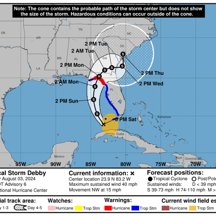
TAMPA, Fla.—Tropical Storm Debby has been upgraded to a Category 1 strength hurricane as it nears landfall along the northeastern Gulf coast, according to the 11 p.m. update from the National Hurricane Center (NHC).
The upgrade was made as maximum sustained winds exceeded 74 mph.
The advisory reported that Hurricane Debby remained about 100 miles west of Tampa, Florida. It was moving due north at approximately 12 mph.
The NHC is predicting landfall within the next few hours and a “gradual decrease in forward speed with a turn toward the northeast and east” to reach the Florida Big Bend coast by Monday morning, and across northern Florida and southern Georgia by Tuesday.
“Weakening is expected on Monday and Tuesday after Debby moves inland,” the forecast added.
On Sunday, residents of the Nature Coast and Big Bend areas were advised to prepare Debby as it approached landfall.
Idalia Brought Wind; Debby Will Bring Rain
Florida Gov. Ron DeSantis said that Debby’s track and expected landing area were similar to what Floridians saw with Hurricane Idalia nearly a year ago. However, he said that the impact will be different.“Idalia was close to a Category Four hurricane,” he said. “It had strong winds that ripped through the Big Bend area, caused a lot of damage, [and] a lot of debris.
“This storm will not have winds that reach the level of Hurricane Idalia, but it is going to produce way more water through the northern part of the state of Florida, and we are looking at potentially really, really significant flooding.”
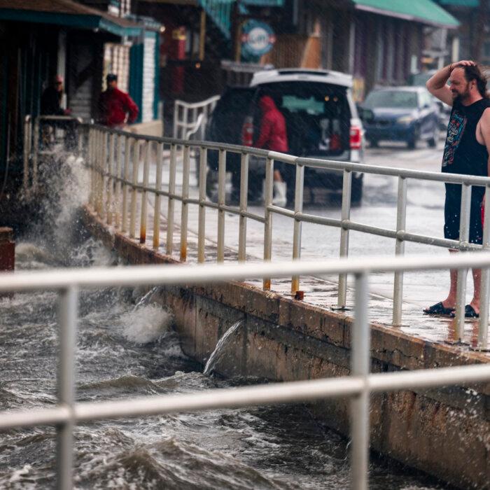
The outer bands of Debby have impacted the west coast of the Florida peninsula throughout Aug. 4 as it makes its way to the panhandle. Several feet of storm surge, Several inches of rain, and instances of active or minor flooding have been observed from as far south as Naples through Cedar Key and the Nature Coast.
Several tornado warnings have also been issued across the state.
Storm surge watches and warnings persist along the Gulf Coast from the Panhandle to Charlotte Harbor. A hurricane warning was extended to Indian Pass, and Mexico Beach is now under a Tropical Storm Warning.
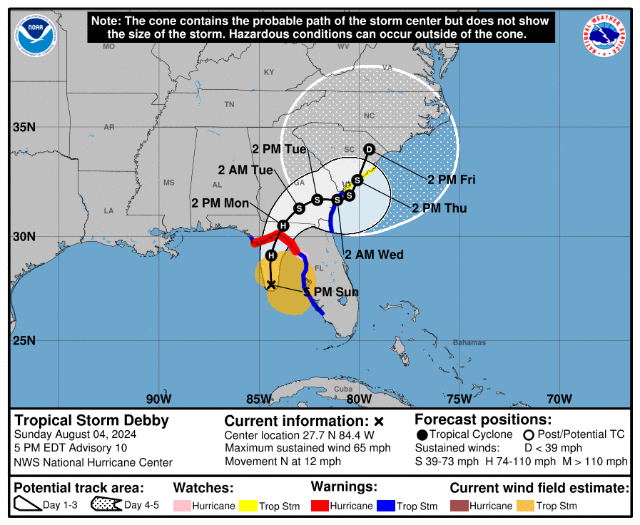
As of the 5 p.m. advisory, tropical storm warnings and storm surge watches are now in effect for the Atlantic coast of Florida, Georgia, and South Carolina. Tropical storm warnings have been discontinued for the Florida coast south of Bonita Beach.
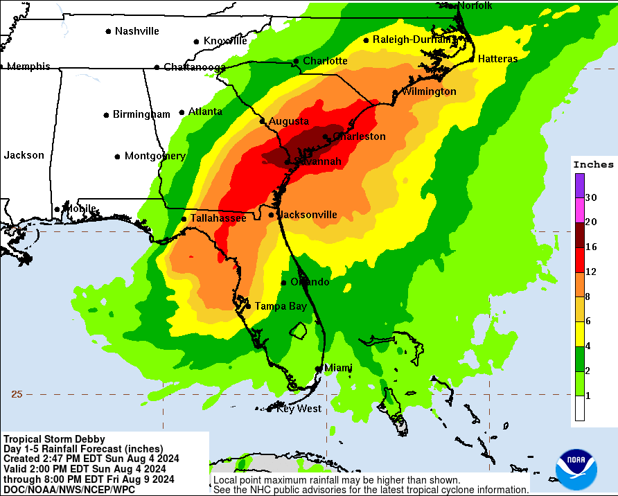
“Across portions of southeast Georgia and South Carolina, 10 [inches] to 20 inches of rainfall, with local amounts to 30 inches, are expected through Friday morning,” the NHC advisory states. “This potentially historic rainfall may result in areas of catastrophic flooding.”
DeSantis and Guthrie said that, given how the outer bands are hitting the peninsula and how the storm could slow and possibly stall on its way to Georgia and the Carolinas, Florida was looking at a multi-day event in terms of the amount of water received.
“It’s never safe to walk or drive through flooded roadways,” Guthrie said. “Not only can it cause accidental drowning, but flood waters are gross and unsafe and can contain many hazards. So please, please make sure that you are not messing around in those flood waters.”
DeSantis announced that this will be the first time that flood control devices will be used to protect utility stations such as substations and wastewater treatment facilities. These devices were previously used to successfully protect hospitals and schools during previous storms.
“This is going to help us respond to and recover more quickly,” Guthrie said at an earlier briefing. “It will also cut down the amount of damage that happens to that public infrastructure.”
However, the governor said that power outages are still expected. As of 5 p.m. on Aug. 4, power outages have been reported in spots up and down southwest Florida, including in Ft. Myers, Tampa, and St. Petersburg.
The Division of Emergency Management has already identified 17,000 linemen who can assist with power restoration. He urged all local governments and utility companies across the state to accept and utilize this extra assistance.
Flooding and wind-swept debris, such as fallen trees, are expected during this storm. DeSantis said that the Department of Environmental Protection has pre-authorized 850 disaster debris management sites for the 61 counties under his emergency declaration.
Emergency Preparations and Evacuations
Preparations for this storm also include the activation of 100 soldiers of the Florida State Guard and 3,000 service members of the Florida National Guard. They are standing by ready to assist in search and rescue operations, humanitarian assistance, road clearance, distribution of commodities, and the protection of critical infrastructure.DeSantis said the Florida National Guard has 10 rotary aircraft and 400 tactical vehicles at their disposal, and the Florida State Guard has nine shallow-water vehicles, 10 UTVs, and two amphibious rescue vehicles.
A dozen swift water rescue teams are prepared, as well as the Florida Fish and Wildlife Conservation Commission’s full fleet of airboats and john boats to assist in any search and rescue as needed.
“We also have on hand for the storm statewide almost 11 million bottles of water, almost 33 million shelf stable meals,” the governor said in his afternoon briefing. “We have pre-staged 670,000 bottles of water, 287,000 shelf stable meals, 3,600 sandbags, and nearly 14,000 tarps in the various parts of Florida.”
More than 115 emergency vehicles have been deployed by the Florida Department of Health to support emergency evacuations and patient transport.
The Florida Department of Transportation (FDOT) is staging resources in the proximity of the storm, ready to clear roadways for power restoration crews and other matters of rapid response.
At FDOT’s disposal, according to the governor, are 1,200 generators for traffic signals and other emergency power transportation needs, 70,000 water pups to mitigate roadway flooding, 230 trucks and pieces of heavy equipment “to support cut-and-toss operations to allow for response personnel to reach impacted areas” and 120 cut-and-toss crews, 120 bridge inspectors, and 150 additional crews for “various emergency response efforts.”
“We’ve been preparing our facilities, making sure travel lanes and shoulders are clear from debris and ready to handle evacuations if they’re ordered,” FDOT secretary Jared Perdue said. “We’ve already extended our Road Ranger service patrol to a 24/7 operation to facilitate people safely moving around and getting where they need to go.”
Mandatory, voluntary, and phased evacuation orders have already been issued or are set to go into effect for parts of Alachua, Citrus, Clay, Dixie, Franklin, Gadsden, Hamilton, Hernando, Jefferson, Levy, Madison, Pasco, Taylor, Union, and Wakulla counties as of 5 p.m. on Aug. 4.
“Execute your plan,” DeSantis said. “If you have been evacuated, [or] if you have been ordered to evacuate by your local officials, please heed that call.”
The governor added that when residents evacuate, they do not have “to drive hundreds of miles,” and there are shelters within each county, including pet-friendly shelters as well as accommodations for people with special needs.
Biden Approves Florida Emergency Declaration
These activations and preparations began on Aug. 1 when DeSantis first declared a state of emergency for 54 counties ahead of Debby’s approach. He would subsequently amend that declaration to include seven more counties.President Joe Biden issued an emergency declaration for Florida, the White House announced in an Aug. 4 statement, as Debby continues to intensify in the Gulf of Mexico.
“Yesterday, President Joseph R. Biden, Jr. declared that an emergency exists in the State of Florida and ordered Federal assistance to supplement State, tribal, and local response efforts due to the emergency conditions resulting from Tropical Storm Debby beginning on August 1, 2024, and continuing,” the White House statement reads.
The White House stated, “Public Assistance (Category B) emergency protective measures, limited to direct Federal assistance, will be provided at 75 percent Federal funding” for all 61 counties.
Of those 61 counties, 38 will also receive “reimbursement for mass care including evacuation and shelter support” at the same percentage.