‘Coast to Coast’ Winter Storm to Hit Millions With Blizzard Conditions, Icing

‘Coast to Coast’ Winter Storm to Hit Millions With Blizzard Conditions, Icing
The U.S. National Weather Service on Monday warned that a "massive winter storm" is anticipated to impact a large portion of the United States this week and present a range of hazards. (NWS)NWS
Jack Phillips
Updated:
0:00

The U.S. National Weather Service (NWS) on Monday warned that a “massive winter storm” is anticipated to impact a large portion of the United States this week and present a range of hazards.

The arctic blast is starting to hit the Pacific Northwest and then push across the northern Rocky Mountains and onto the Great Plains. It will bring heavy snow and strong winds, the National Weather Service said. Temperatures will drop drastically after Tuesday leading to dangerous wind chills, the weather service said.
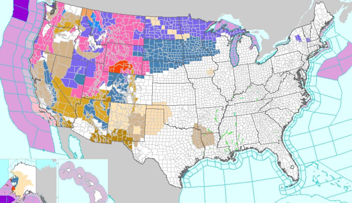
According to a map posted by the NWS on Monday, winter storm warnings, blizzard warnings, and winter storm watches are in effect for many counties in the Rocky Mountain states. Warnings and watches were also issued for South Dakota, North Dakota, Wisconsin, Iowa, Nebraska, Minnesota, and Michigan’s Upper Peninsula.

“A broad swath of accumulating snow is expected across northern Minnesota, Wisconsin, and the Upper Peninsula of Michigan,” according to the NWS’s bulletin. “Some locally heavier totals will be possible in favorable lake and higher elevation locations across the Upper Peninsula of Michigan. Portions of the Upper Midwest will see little break between this system and impacts from the major winter storm approaching immediately thereafter.”

That system will then bring some snowfall to the upper portions of the Northeast United States later this week, according to The Weather Channel’s forecast.
As of Monday, winter storm warnings span from Washington to California, along with Nevada to Montana. Blizzard warnings are in effect for parts of southern Wyoming, while winter storm watches are in effect from Arizona to the Plains and Upper Midwest regions.

Impacts

“A major multiday winter storm will affect areas from the West Coast through the Upper Midwest Monday through Thursday with heavy snow and considerable impacts,” the NWS stated. “Snow, sleet, and freezing rain may spread into the Great Lakes and Northeast later this week.”

Widespread travel impacts and possible power outages should be expected, the NWS said.

“This looks to be a long duration storm, with things starting to pick up in the North West tonight and into the day Tuesday,” Rich Otto, with the NWS, told the Wall Street Journal.

“Lots of snow is expected for the western U.S. that will spread across to the east,” he continued. “It’s essentially a coast to coast winter storm that’s going to continue through Friday.”

Forecasters with AccuWeather said there is a very slight potential the storm brings snow to Chicago, Detroit, Boston, and cities along the way.

“The chance of this storm and others to bring snow and/or ice to Washington, D.C., and Philadelphia is very low through the first part of March,” AccuWeather’s Joe Lundberg said. “For now, outside of the higher terrain in the Appalachians, Interstate 80 may be the southernmost cutoff for snow and ice with the storm later this week.”

“High pressure and the associated northward bulge in the jet stream across the Southeastern states will be very strong this week and should work to keep the storm track well to the north,” Lundberg also said. “As long as that holds up, it is going to be very hard to get snow to fall from New York City to DC. North of there, the chances are [looking] much better.”

The Associated Press contributed to this report.
Jack Phillips
Jack Phillips
Breaking News Reporter
Jack Phillips is a breaking news reporter who covers a range of topics, including politics, U.S., and health news. A father of two, Jack grew up in California's Central Valley. Follow him on X: https://twitter.com/jackphillips5
twitter
Related Topics