Acting Texas Gov. Dan Patrick addressed his state from the Texas Division of Emergency Management after hurricane-turned-Tropical Storm Beryl, bore down on southeast Texas.
“I think every storm is a lesson,” he said.
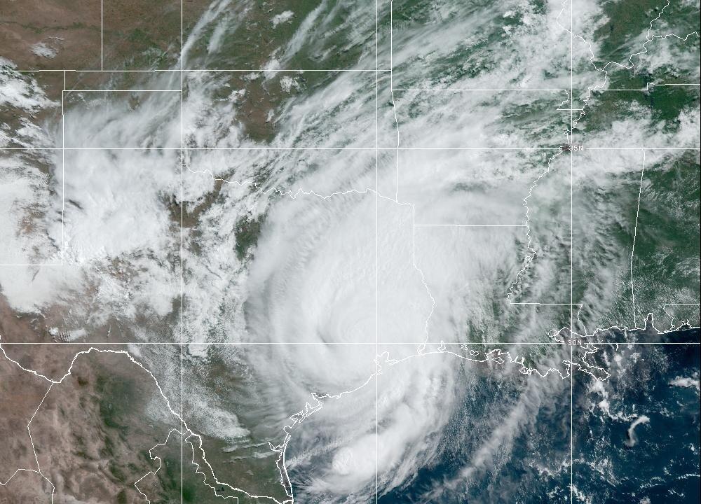
While this storm was only a Category 1 or a tropical storm on paper, the combination of 80 mph winds, six to 10 inches of rain, and storm surge, not to mention tornadoes, “that might as well be a Cat 5 storm if you’re in the middle of it.”
Mr. Patrick confirmed three fatalities in the state–two who were killed by trees falling on their homes, and one city employee who drowned in floodwaters–and said that more than 2.7 million people were without power, with 10 transmission lines down.
He was joined by Emergency Management Chief Nim Kidd and Tom Gleason from the Public Utility Commission to tell Texans to get to the safest place possible and prepare for a multi-day recovery effort.
Mr. Patrick said CenterPoint Energy was bringing in 11,500 workers from other parts of Texas and other states to assist in getting power back up.
Mr. Gleason confirmed, “We’re entering the assessment phase of this storm,” and crews will start assessing the damages as it is safe to do so with the storm’s passing.
Mr. Kidd confirmed that more than 2,500 first responders were deployed across the state to respond to emergencies and distribute pre-staged resources.
He also said that an emergency medical task force will move patients from hospitals and assisted living facilities to safe locations with power. His team was ready to open more shelters as needed, as well as cooling centers “as the heat sets in.” The centers will provide locals with food, water, and ice.
The three officials also affirmed that the ordeal was not done yet. On top of the immense power loss, heavy rain continues to fall in northeast Texas, which Mr. Patrick said will feed into the rivers, travel back down to the coast, and add to the flooding already seen in Houston in the coming days.
They also encouraged people stay off the roads while the flooding persists, watch out for downed power lines, and be mindful of carbon monoxide poisoning that can come from running generators in their homes.
Tornadoes were also mentioned.
Northern Louisiana and East Texas became a hotbed for tornadoes in the early afternoon of July 8 as Tropical Storm Beryl continued on its track towards the Mississippi River.
The National Hurricane Center (NHC)’s 4 p.m. CT advisory reported that Beryl had turned further to the east and sped up to 16 mph, although its maximum sustained winds had decreased to 45 mph.
While its overall power decreased, Beryl’s outer bands have produced several tornado-producing thunderstorms over the past few hours, with wind speeds as fast as 50 mph.
Since the NHC’s 1 p.m. advisory, the National Weather Service (NWS) has reported more than 40 individual tornado warnings, with tornadoes either observed or rotations from tornadic thunderstorms indicated by radar. Instances of small hail have also been reported.
As of 6 p.m. CT, a tornado warning was still in effect for parts of Red River, Caddo, Bienville, Natchitoches, and Bossier Parishes, as well as parts of Arkansas’s Calhoun, Ouachita, Hempstead, Lafayette, Nevada, and Columbia Counties.
A tornado was confirmed near Buckner, Arkansas, at 5:36 p.m. CT, moving northwest at 35 mph.
Another tornado was confirmed at 4:27 p.m. CT seven miles south of Mansfield, Louisiana, moving north at 40 mph.
At 4:23 p.m. CT, the NWS confirmed a “large and extremely dangerous tornado” was located near Fouke, Louisiana, moving northwest at 40 mph.
At 4:15 pm. CT, a tornado was confirmed to be on the ground in Hughes Springs, Texas.
A tornado’s strength is measured by the Enhanced Fujita (EF) scale, ranging from EF-0 (funnels producing three-second wind gusts of 65-85 mph) to EF-5 (three-second gusts of over 200 mph). It is unclear where on the scale these tornadoes fall at the time of this article’s publication.
The Epoch Times has contacted Louisiana Gov. Jeff Landry’s office and the Ochsner LSU Health Shreveport—Academic Medical Center regarding the expected response to the tornadoes.
Tropical Storm Beryl is expected to leave Texas for Arkansas late Monday night but it is still expected to drop four to eight inches of rain on portions of eastern Texas, with localized amounts of 12 inches.
“Considerable flash and urban flooding, as well as minor to isolated major river flooding, is expected,” the NHC stated.
Three to five inches of rain is also expected to fall in the surrounding states of Oklahoma, Arkansas, and Missouri.
Flood warnings and watches extend northeast past Memphis, Tennessee; and St. Louis, Missouri; covering much of southern Missouri and southern Illinois up to Indiana. The National Weather Service said the flood watch will remain in effect until July 10.
A storm surge warning is active for Galveston Bay in Texas and the surrounding coastline.
“We’re not past any flooding,” said. Mr. Patrick. “We’re not past difficult conditions, but the storm by midnight will be beyond us.”
Mr. Patrick is Texas’ lieutenant governor, operating as acting governor, while Gov. Greg Abbot is on a pre-planned economic mission to Japan, Taiwan, and South Korea. Mr. Patrick has participated in the response to several previous storms as a senator and lieutenant governor.