Back-to-Back Hurricanes: Hawaii Could Face Gilma Less Than a Week After Hone

Tropical Storm Hone began its pass of the islands as a Category 1 Hurricane on Aug. 25, diminishing to a tropical storm in the process.
Back-to-Back Hurricanes: Hawaii Could Face Gilma Less Than a Week After Hone
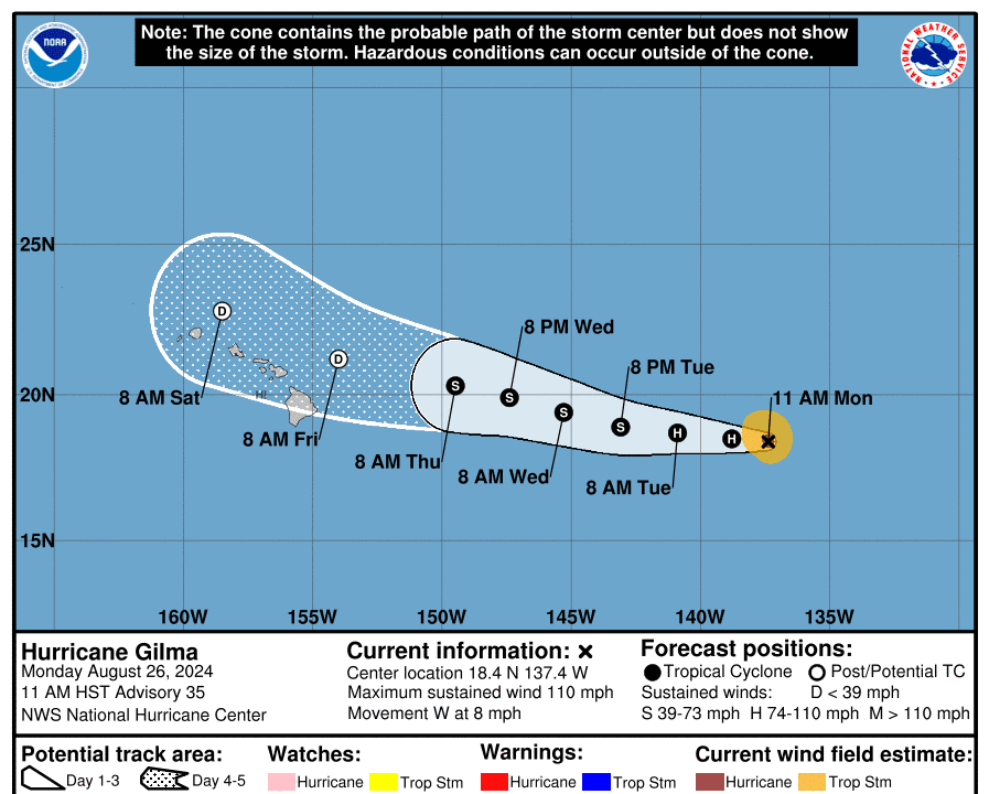
National Hurricane Center's forecasted track for Hurricane Gilma on its way toward Hawaii as of 5 p.m. Eastern time on Aug. 26, 2024. National Hurricane Center/National Weather Service
T.J. Muscaro
Updated:
0:00

The Hawaiian Islands could face back-to-back storms as the National Hurricane Center (NHC) forecasts Hurricane Gilma to arrive within striking distance by Labor Day Weekend—less than one week after Hurricane Hone.

Ian Morrison, the forecaster at the National Weather Service’s Honolulu office, told The Epoch Times that “it’s not unprecedented” to see storms come five days apart when “the East Pacific gets active with generating storm after storm,” but it is not a yearly occurrence.
Pacific hurricanes tend to form in the eastern Pacific off the coast of Mexico and travel westward, he said. There are currently three named storms in the Pacific, with Tropical Storm Hector following behind Gilma.

According to the NHC’s advisory released at 11 a.m. local time (5 p.m. Eastern), Hurricane Gilma was spotted 1,160 miles east of Hilo, Hawaii, with winds of 110 mph. It’s moving slowly across the ocean at 8 mph and is forecasted to be situated just north of the Island of Hawaii, also known as “The Big Island,” on the morning of Aug. 30, having diminished to a post-tropical depression.

The NHC reports a slight increase in intensity since the last advisory, stating, “Gilma’s eye continues to become more symmetric with a warming eye and impressive convection surrounding the eye.”  However, it also predicts a gradual weakening of the storm to begin tonight, “with a more steady rate of weakening” starting Aug. 27 and Gilma becoming a post-tropical storm in the next four days.

Morrison told The Epoch Times that the weakening would be due to increased wind shear and colder waters. Gilma is expected to stay on the northern side of the islands, while Hone’s path stays to the south.

Gilma reached its maximum strength as a Category 3 Hurricane on Aug. 22, recording sustained winds of up to 125 mph. Once its remnants reach the vicinity of Hawaii, it is expected to dispense a significant amount of rain but lack the tropical-storm-force winds that came with Hone.

“We are hoping for the rain now to kind of update the drought conditions we have on the leeward side for the island,” Morrison said.

However, Morrison said it’s too soon to tell more precisely how Gilma will affect the Hawaiian Islands.

“It’s hard to say with it still being ... five days out in the forecast,” he said. “And with the weakening system, it’s also more difficult to predict the track because it’s getting sheared apart.”

Tropical Storm Hone began its pass of the islands as a Category 1 Hurricane on Aug. 25, diminishing to a tropical storm in the process. It was still impacting the islands on the morning of Aug. 26, with radar imagery showing the outer bands still bringing overcast skies and showers to the islands of Oahu and Kauai. As of the NHC’s 11 a.m. advisory, it was 280 miles west-southwest of Honolulu, departing the archipelago at a speed of 16 mph.
Hone delivered its biggest wallop to the Big Island, the only island to suffer tropical-storm-force winds (up to 70 mph). As much as 20 inches of rain was recorded around the city of Hilo and the larger eastern and southeastern sides. Flash flood warnings were issued for most of the island, and thousands of residents lost power across several islands. Damage assessments are underway.