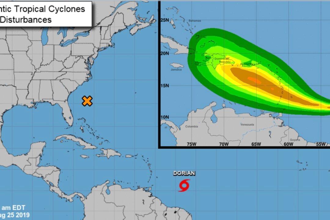
The U.S. National Hurricane Center said Tropical Storm Dorian has formed in the Atlantic and could reach hurricane strength by Tuesday.
Storm Warning and Storm Watches Issued
As Dorian moved west toward the Caribbean on Sunday morning, the inclement weather system embedded Barbados under a tropical storm warning and other Caribbean islands under tropical storm watches.The first key message conveyed by the hurricane center in the 11 a.m. advisory was the issuance of a Tropical Storm Warning for Barbados and a Tropical Storm Watch for St. Vincent and the Grenadines. Additionally, the government of St. Lucia has issued a Tropical Storm Watch.
The second key message was that it’s too early to forecast the specific timing and magnitudes of the impacts in Puerto Rico, the Virgin Islands, or Hispaniola. Authorities and interested parties in those regions should monitor the progress of the storm.
Tropical-Storm-Force Winds
The hurricane center said that maximum sustained winds are near 40 mph with higher gusts. With some strengthening during the next 48 hours, Dorian could be near hurricane strength. By Tuesday, Dorian could be around hurricane strength over the eastern Caribbean Sea, the center noted.Tropical-storm-force winds extend outward up to 25 miles from the center of the cyclone.
“Dorian is expected to produce total rain accumulations of 2 to 4 inches in portions of the Lesser Antilles, with possible isolated maximum amounts of 6 inches,” the hurricane center said.
“Swells generated by Dorian will be affecting portions of the Lesser Antilles by late Monday,” the center added. “These swells could cause life-threatening surf and rip current conditions.”
The hurricane center has published Coastal Watches/Warnings and a Forecast Cone Storm Center graphic, which shows the probable path of the storm center.
The center says: “this graphic shows an approximate representation of coastal areas under a hurricane warning (red), hurricane watch (pink), tropical storm warning (blue) and tropical storm watch (yellow).”
The hurricane center has published an Atlantic 5-Day Weather Outlook graphic with supplementary text.
“Environmental conditions appear conducive for gradual development, and a tropical or subtropical depression is likely to form within the next few days while the system moves slowly northeastward well offshore of the southeastern United States,” the center stated.
The hurricane center adds people should additionally consult products from local weather offices.
The area of disturbed weather, dubbed Invest 98L by the hurricane center, wandered over the Florida Peninsula on Saturday and brought localized downpours to eastern parts of the state.
“As 98L begins to move northeastward away from Florida, conditions should be conducive for further development and organization of this system over the next few days as it moves through a zone of warm water and fairly low wind shear,” AccuWeather Senior Meteorologist Dan Pydynowski said.
Dorian is the fourth tropical storm in the Atlantic this year and is poised to become the first hurricane this season.