Photos: Fort McMurray Fire, Devastating Before-and-After Satellite Images

Photos: Fort McMurray Fire, Devastating Before-and-After Satellite Images
Comparison of satellite images taken before (L) and after wildfires hit Fort McMurray in Alberta, Canada, in May 2016. Screenshots of Google Crisis Map
Petr Svab
Updated:

See full coverage of the Fort McMurray wildfires here

The wildfires in the Fort McMurray area, Alberta, Canada, are not yet under control, but firefighters are hoping the weather will help quell the spread. 

A May 8, 4:15 p.m. update on an official Alberta website, said the fire was spread over 161,000 hectares (over 620 square miles).

“Fire conditions remain extreme, with four new starts across Alberta yesterday,” the update reads.

A total of 34 wildfires are burning, with five out of control.

The sky over the city was clear enough on Friday for a satellite to capture images that reveal, to some extent, the damage Fort McMurray suffered during the fire.

The images taken after the fire were enhanced for increased contrast, clarity, and sharpness.

This is the before and after image of the River View Heights and Hilltop Estates neighborhoods in the central part of the city by the Athabasca River.

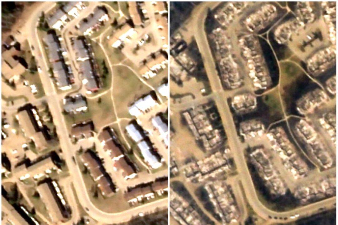
River View Heights and Hilltop Estates neighborhoods in the central part of the city by the Athabasca River. The image on the left was taken on May 1, before the fire. The image on the right was taken on May 5, 2016. (Screenshots of Google Crisis Map)
River View Heights and Hilltop Estates neighborhoods in the central part of the city by the Athabasca River. The image on the left was taken on May 1, before the fire. The image on the right was taken on May 5, 2016. Screenshots of Google Crisis Map


These are the neighborhoods of Hillview Park, Arsenault / Adrian, Abasand Heights, Patio Homes East, and Hangingstone Place.

The neighborhoods of Hillview Park, Arsenault / Adrian, Abasand Heights, Patio Homes East, and Hangingstone Place in Fort McMurray, Alberta, Canada. The image on the left was taken May 1, before the fire, and the right image was taken May 5, 2016. (Screenshots of Google Crisis Map)
The neighborhoods of Hillview Park, Arsenault / Adrian, Abasand Heights, Patio Homes East, and Hangingstone Place in Fort McMurray, Alberta, Canada. The image on the left was taken May 1, before the fire, and the right image was taken May 5, 2016. Screenshots of Google Crisis Map

This is the Waterways area.

The Waterways area. The image on the left was taken May 1, before the fire, and the right image was taken May 5, 2016. (Screenshots of Google Crisis Map)
The Waterways area. The image on the left was taken May 1, before the fire, and the right image was taken May 5, 2016. Screenshots of Google Crisis Map

Petr Svab
Petr Svab
reporter
Petr Svab is a reporter covering New York. Previously, he covered national topics including politics, economy, education, and law enforcement.
twitter
Related Topics