Hurricane Nicholas Makes Landfall in Texas

Hurricane Nicholas Makes Landfall in Texas
A satellite image shows Tropical Storm Nicholas in the Gulf of Mexico, on Sept. 12, 2021. NOAA/Handout via Reuters
Isabel van Brugen
Updated:

Hurricane Nicholas made landfall in Texas early on Tuesday, with the anticipated heavy rain, storm surge, and high winds potentially causing widespread and life-threatening flooding to the Gulf Coast of Texas and Louisiana through the middle of the week.

According to the National Hurricane Center (NHC) in Miami, Nicholas strengthened from a tropical storm into a hurricane late on Monday. The Category 1 hurricane hit the eastern part of the Matagorda Peninsula, about 10 miles (17 kilometers) west-southwest of Sargent Beach, at maximum winds of 75 mph (120 kph).
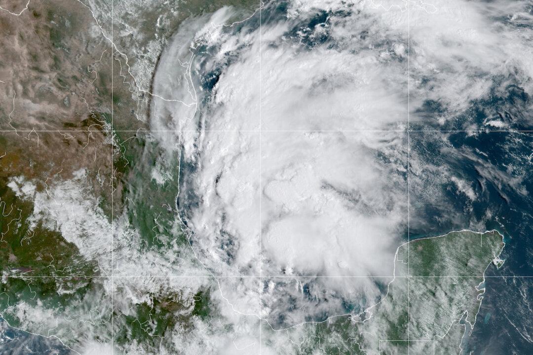
Portions of southeastern Texas, Louisiana, and southern Mississippi are expected to be impacted by heavy rainfall, the NHC said late Monday, warning of potential life-threatening flash and urban flooding along the eastern Texas coast into southwestern Louisiana.

The center said there is also danger of life-threatening storm surge inundation along the Texas coast from Port Aransas to Sabine Pass, and advised residents in these areas to follow advice given by local officials.

“It will be a very slow-moving storm across the state of Texas that will linger for several days and drop a tremendous amount of rain,” Texas Gov. Greg Abbott said in a statement on Monday afternoon. “People in the region need to be prepared for extreme high-water events.”

Abbott announced that he will declare states of emergency in 17 counties and three cities across coastal Texas, adding that boat and helicopter rescue teams have been deployed or placed on standby.

Rainfall totals of up to 16 inches and possibly 20 inches in some isolated areas were forecast for parts of Texas through Wednesday. As Nicholas moves northeast, it was expected to dump as much as 10 inches on parts of south central Louisiana and southern Mississippi through Thursday, the NHC said.

The National Weather Service issued storm surge, flood, and tropical storm warnings and watches throughout the region, calling it a “life-threatening situation.”

“Rain will be heavy at times through midweek across parts of southeast Texas and Louisiana,” said AccuWeather Meteorologist Alyson Hoegg.

With landfall expected in just hours, the region is still struggling to recover from Hurricane Ida, which caused widespread damage and power outages in late August.

One of the most powerful hurricanes ever to strike the U.S. Gulf Coast, Ida tore a devastating path of destruction and crippled the New Orleans power grid. It claimed the lives of more than two dozen people as it devastated communities in Louisiana near New Orleans.

“We want to make sure that no one is caught off guard by this storm,” Louisiana Gov. John Bel Edwards told reporters on Monday afternoon. “Heavy rainfall will be the primary concern.”

The governor warned that drainage systems still clogged with debris from Ida and other recent storms may not be able to handle the expected deluge of rainwater, causing flash flooding.

Teams of rescue workers with high-water vehicles and boats were prepared to respond to people trapped by flooding across southern Louisiana, Edwards said.

Houston’s 2.3 million residents have been urged to remain at home amid expected rainfall of 8 inches.

“Take things seriously and prepare,” Houston Mayor Sylvester Turner said during a press briefing. “This is primarily a rain event and we don’t know how much rain we will be getting.”

According to PowerOutage.us, roughly 95,000 power outages in Louisiana were reported shortly after midnight on Tuesday, while more than 79,000 households and businesses were without power in Texas.
Reuters contributed to this report.
Isabel van Brugen
Isabel van Brugen
Reporter
Isabel van Brugen is an award-winning journalist. She holds a master's in newspaper journalism from City, University of London.
twitter
Related Topics