Magnitude 6.5 Earthquake Rattles East Timor near Indonesia

Magnitude 6.5 Earthquake Rattles East Timor near Indonesia
A magnitude 6.5 earthquake struck the coast of East Timor on May. 27, 2022. U.S. Geological Survey
Aldgra Fredly
Updated:

The coast of East Timor, also known as Timor Leste, was rattled by a 6.5-magnitude earthquake early May 27, according to the Indonesian Meteorology, Climatology and Geophysics Agency.

The agency did not issue a tsunami threat warning, and there have been no immediate reports of casualties or damage so far.
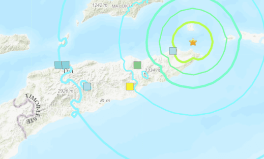
It stated that the quake was centered 85 kilometers (53 miles) south of the coast of Maluku, at a depth of 104 kilometers (65 miles).
Meanwhile, the U.S. Geological Survey (USGS) reported that the quake magnitude was 6.2 and 49 kilometers (30 miles) deep.

The earthquake was felt by residents in the Australian city of Darwin, more than 700 kilometers (435 miles) away from the earthquake’s epicenter, according to Australian media reports and residents’ posts on social media.

The Australian Bureau of Meteorology said the tremor did not trigger a tsunami threat warning in Australia despite its proximity, local news outlet Katherine Times reported.

East Timor and neighboring Indonesia straddle the so-called “Pacific Ring of Fire,” a seismically active zone where different plates on the earth’s crust meet and create a large number of earthquakes and volcanoes.

East Timor comprises the eastern half of Timor island, the western half of which is part of Indonesia. It has a population of approximately 1.3 million. The nation is Southeast Asia’s youngest country, having gained independence from Indonesia in 1999.

Reuters contributed to this report.
Aldgra Fredly
Aldgra Fredly
Author
Aldgra Fredly is a freelance writer covering U.S. and Asia Pacific news for The Epoch Times.
Related Topics