Storms have started hitting areas of at least four states, while the National Weather Service warns of intense tornadoes and baseball-sized hail.
5:45pm- Hail in Cleo Springs, north of Fairview, in NW OK. Picture from @Okbombsquad. #okwx @NEWS9 pic.twitter.com/zj5mVbSKJk
— Matt Mahler (@themahler) April 26, 2016
Hail in Southeast Wichita. @KWCHRoss @NWSWichita pic.twitter.com/cWqtIPFJ8N
— SMG Photos (@SusanaPhotos) April 26, 2016
What a beast! Near Manitou, OK. #okwx @NWSNorman @kevinselle pic.twitter.com/08xsKmpavq
— StormWarriorsTV (@StormWarriorsTV) April 26, 2016
Parking lot on K-state campus in Manhattan. Campus is closed. #wibw #kswx pic.twitter.com/OLA5ZIXz5i
— Jace Mills (@wibwJace) April 26, 2016
Storm cell is darkening as it’s moving it’s way north to Wichita. Hail is falling and accompanied by lightening. pic.twitter.com/4Ywuk1h1zf
— Avery Anderson (@AAndersonKSN) April 26, 2016
Live feed of a tornado nearly touching down SW of Wichita! #KSwx pic.twitter.com/YaFZzEt7Y7
— Ethan Narber, PIC ✈ (@EthanNarber) April 26, 2016
1“ to occasional 1.75” hail for about 3-5 minutes in duration around 0730 CDT at MCI. #MOwx #KansasCity pic.twitter.com/ym8qwik5o7
— C.T. Thongklin (@CThongklin) April 26, 2016
Just outside Wakita. No twister yer @KATVToddYak pic.twitter.com/yDWx6O4Oxy
— Brian Emfinger (@brianemfinger) April 26, 2016
About 7 miles south of Mayfield, looking NW #kswx pic.twitter.com/YBE6Q0FOhw
— Beth Bowdoin (@skewy11) April 26, 2016
Quarter sized hail in Crowell, TX (Photo: Sharyn Hake- Humphrey) pic.twitter.com/VK0uHqdbY9
— Gillian Jones (@Gill_Jones13) April 26, 2016
“Numerous severe thunderstorms expected to rapidly form in the next couple hours,” the NWS stated at 2:30 p.m. (CT) on April 26. “This is a particularly dangerous situation.”
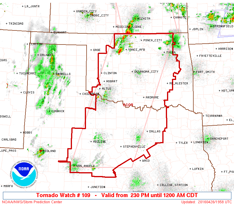
Tornado watches have been issued for parts of Oklahoma, Texas, Kansas, and Nebraska.
A tornado watch has been issued for parts of Oklahoma and Texas until 12 AM CDT pic.twitter.com/c9qWhwqFfq
— NWS Tornado (@NWStornado) April 26, 2016
A tornado watch has been issued for parts of Kansas and Nebraska until 9 PM CDT pic.twitter.com/cJp10gCm3d
— NWS Tornado (@NWStornado) April 26, 2016
Severe thunderstorm alerts have been issued for areas in Missouri, Illinois, Indiana, Kentucky, Pennsylvania, and New Jersey.
Oklahoma City Public Schools dismissed students early on Tuesday.
All after school activities have been cancelled and schools will dismiss 30 minutes early. #okwx pic.twitter.com/NzCAspEPGT
— OKC Public Schools (@OKCPS) April 26, 2016
Four miles south of Mayfield, KS. Wall cloud becoming more defined. #kswx pic.twitter.com/6aL6lMtjF9
— Justin Dean (@sprtsnwthrguy) April 26, 2016
Just NW of Caldwell looking west #kswx pic.twitter.com/9Nwu5XNGGk
— Beth Bowdoin (@skewy11) April 26, 2016
Straight west of Wellington moving ne. #kswx pic.twitter.com/fT5m4mmMsD
— Travis Heying (@travisheying) April 26, 2016