Ten years on from the devastating Boxing Day earthquake and tsunami, our understanding of very large earthquakes has grown enormously. From satellites monitoring changes on the Earth’s surface to drilling deep below the ocean floor, new techniques are constantly being developed to help us figure out why earthquakes are sometimes so big, and so deadly.
The 2004 earthquake ruptured the fault marking the contact between two tectonic plates at a subduction zone, where one plate slides beneath another – the locations on Earth where the very largest earthquakes and tsunami are generated.
Before 2004, the last earthquake of magnitude nine or larger occurred in 1964, in Alaska. However in the past decade there have been several very large quakes, including Chile in 2010 and the 2011 Tohoku-oki earthquake in Japan that caused the Fukushima nuclear power station meltdowns.
We know a great deal more about these recent events than we did the Alaska earthquake as, not surprisingly, the technology we use is a lot more advanced than in the 1960s. Satellites can now track the movement of the Earth’s surface during, before and after an earthquake using GPS, and they can track a tsunami wave in the deep ocean. Techniques to record the earthquake waves and to resolve the details of the earthquake fault slip are now much more sophisticated. And we can gain much higher resolution details of geological layers and structure under the seafloor, helping us find out more about earthquake faults.
Slipping and Sliding
The 2004 earthquake occurred when the Indian plate slipped beneath the Sunda plate. Though scientists were well aware this was an active fault line, the plate slipped over a much larger area and further into the shallow fault zone than anticipated.
The 2011 Japan earthquake and tsunami that followed was even more unexpected in character: the fault slipped into its very shallowest section and the slip was the greatest ever recorded on a fault – the fault (and in turn the overlying seabed) moved by up to 50-60m. To put this into context, in a “typical” large earthquake, the fault slips by about 5-10m and still causes very damaging effects.
For the first time, equipment on the seafloor offshore Japan in 2011 measured the changes in pressure as the seafloor moved, and was able to record the magnitude of the fault slip. This very large and shallow slip certainly amplified the tsunami, leading to devastating results.
These recent earthquakes have truly called into question the existing models for very large earthquake generation and have resulted in scientists rapidly generating new ideas and re-examining the hazard potential at other subduction zones around the world.
Drilling for the Answers?
Although we now have very sophisticated techniques to remotely record the earthquake process and the geology below the seafloor, we really need to sample the fault rocks themselves, where the real action goes on and where earthquakes are generated, typically 5km or more below the surface or seafloor.
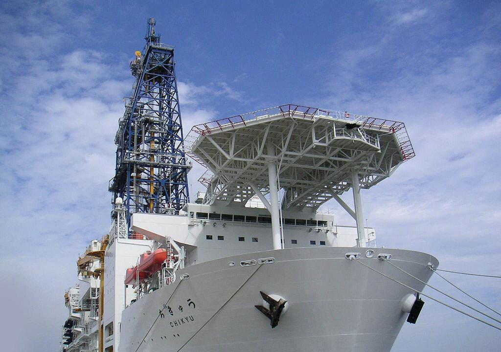
Sampling this zone “in situ” is one of the holy grails of modern fault and earthquake studies – and the only way to do this is through ocean drilling using the same techniques as the petroleum industry.
In the past 10-15 years projects tackling active faults and the earthquake process, particularly at subduction zones, have increased in number and in the boldness of their objectives, drilling in very challenging conditions.
Drilling is ongoing on the tectonic plate margin of Japan as part of the NanTroSEIZE programme, south of the region affected by the 2011 earthquake. Scientists have drilled lots of boreholes to sample different parts of the system and the project is currently 2km from the primary target fault zone. This part of the Japanese plate boundary generates damaging tsunami-genic earthquakes about every 150-200 years and the project will not only sample the fault rocks but also continuously monitor the fault to help reduce potential risk.
Further north along the Japan coast, and soon after the 2011 earthquake, a team of scientists rapidly prepared a ship to drill through the shallow fault where the extremely large slip occurred. The rock samples they brought back to the ship were unexpectedly weak and we now believe this is why there was such large and shallow slip.
Finding the Next Mega-earthquake
Weakness of the earthquake fault may be the answer for the surprising 2011 earthquake but what about other subduction zones?
A drilling expedition will sail to the tectonic margin off Sumatra in 2016 to drill into the sediments supplying the fault zone that generated the 2004 earthquake. Here we hypothesise that the sediments may be especially strong and that this resulted in shallower fault slip than expected – the opposite to what has been proposed for the Japan 2011 earthquake fault.
If both theories are correct, we will need to revisit global subduction zones to re-assess sediment and fault properties and how these faults may slip in future.
Since the 2004 earthquake and tsunami we’ve learned a lot but, as is often the case in science, we now have new questions to answer. However new technology is giving us the ability to answer them – this is a very important time to be an Earth scientist.
![]()
This article was originally published on The Conversation. Read the original article.
