")
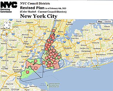
NEW YORK—The city’s Districting Commission has redrafted the map delineating new council district lines after harsh criticism threw an earlier version that was nearly finalized back to the drawing board.
Late last year City Council Speaker Christine Quinn told the commission in a series of letters between her and chairman Benito Romano it should withdraw its final draft and prepare a new one.
Romano agreed. The commission has now released its latest draft, and will discuss the revised plan at a public meeting on Feb. 6 before voting on it.
Good government groups are divided about the newest version. Citizens Union commended the commission for releasing a staff document that details its decision-making process and for releasing the maps ahead of the public meeting.
The map is revised once every decade and can drastically change elections for City Council members in some districts. Changes to the map are guided by city and federal laws, including the 14th Amendment, which allows one person, one vote; the Voting Rights Act, which prohibits discrimination, including diluting minority voting strength; and a section in the city’s charter that includes fair representation of racial minorities and balancing districts based on population size.
For the latter criteria, the difference between the least populous district and the most populous district can be no more than 10 percent of the average district size.
As opposed to the map the commission put forward late last year, the new map is transparent and outlines analysis of different factors such as requests made by the public, according to Citizens Union.
“This welcomed step not only corrects the commission’s earlier stumbles when it released its last set of plans, which appeared to bend to the political interests of individuals, but also adds to the laudable record built by the commission,” the organization said in a statement.
The Asian American Legal Defense and Education Fund, which put forward a so-called Unity Map, said it is still not happy with the newest map, according to Jerry Vattamala, staff attorney.
Vattamala said Asian communities in Bensonhurst, Queens; Bayside, Brooklyn; Chinatown, and the Lower East Side in Manhattan are still divided in the newest iteration of the map.
Why?
“There’s a lot of political pressure,” he said in an interview. Though he appreciates the efforts of the commission, “The end result is a little too much political influence, and it shows, and where it shows the most is Bayside and Bensonhurst.”
The public meeting, which will not include public testimony, takes place Tuesday, Feb. 6, at 6 p.m., at the New York Law School.
The Epoch Times publishes in 35 countries and in 21 languages. Subscribe to our e-newsletter.
Please send news tips to [email protected]