Landsat 5 Satellite Images Show Fires and Flooding (Photos)

The Landsat Program’s Earth-observing satellites, managed by NASA and the USGS, are helping emergency managers to gather information about natural disasters, such as the Mississippi floods and Arizona’s largest-ever fire.
Landsat 5 Satellite Images Show Fires and Flooding (Photos)
Epoch Times Staff
Updated:
False-color Landsat 5 satellite images on June 11, 2011 (left) and June 18, 2008 with water in navy blue, and land in green or burnt orange according to use. Move the slider left and right to compare water levels. (Presented by NASA using Landsat data from the USGS)


The Landsat Program’s Earth-observing satellites, managed by NASA and the USGS, are helping emergency managers to gather information about natural disasters, such as the Mississippi floods and Arizona’s largest-ever fire.

The Mississippi reached record levels on May 19, hitting a height of 57.10 feet (17.40 meters) at Vicksburg. The river was still in minor flood stage on June 14, with levels continuing to drop.

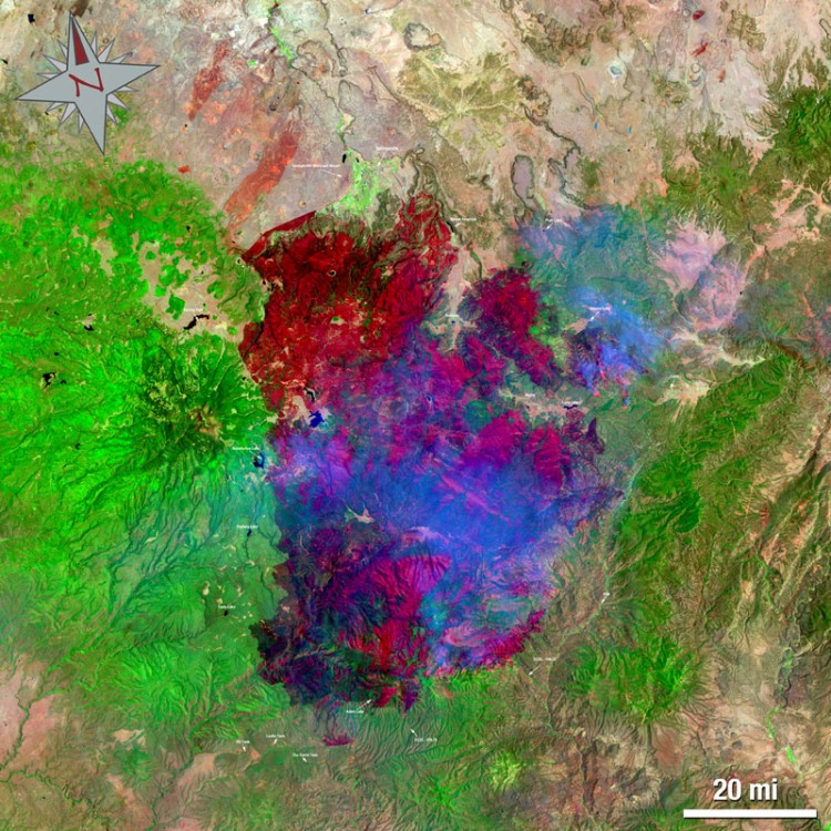
Meanwhile in Arizona, the Wallow fire has been spreading since May 29 via high winds and low humidity, and has burned nearly half a million acres of land to date. The Horseshoe 2 fire has damaged almost 200,000 acres since it began on May 8.

The Landsat satellite series has been gathering data about Earth since 1972, with the next satellite due to launch in December 2012.

<a><img src="https://www.theepochtimes.com/assets/uploads/2015/09/560089main_Arizon_Wallow_800.jpg" alt="The Wallow North Fire in east central Arizona on June 15. This false-colored image uses a 7, 4, 2 band combination and shows the burn scar in red the fire ongoing in really bright red, vegetation is green, smoke is blue and bare ground is tan. (NASA/USGS, Mike Taylor)" title="The Wallow North Fire in east central Arizona on June 15. This false-colored image uses a 7, 4, 2 band combination and shows the burn scar in red the fire ongoing in really bright red, vegetation is green, smoke is blue and bare ground is tan. (NASA/USGS, Mike Taylor)" width="575" class="size-medium wp-image-1802531"/></a>
The Wallow North Fire in east central Arizona on June 15. This false-colored image uses a 7, 4, 2 band combination and shows the burn scar in red the fire ongoing in really bright red, vegetation is green, smoke is blue and bare ground is tan. (NASA/USGS, Mike Taylor)

<a><img src="https://www.theepochtimes.com/assets/uploads/2015/09/560091main_Arizona_Horseshoe_800.jpg" alt="The Horseshoe 2 Fire in southeastern Arizona on June 15. This false-colored image uses a 7, 4, 2 band combination and shows the burn scar in red the fire ongoing in really bright red, vegetation is green, smoke is blue and bare ground is tan. (NASA/USGS, Mike Taylor)" title="The Horseshoe 2 Fire in southeastern Arizona on June 15. This false-colored image uses a 7, 4, 2 band combination and shows the burn scar in red the fire ongoing in really bright red, vegetation is green, smoke is blue and bare ground is tan. (NASA/USGS, Mike Taylor)" width="575" class="size-medium wp-image-1802533"/></a>
The Horseshoe 2 Fire in southeastern Arizona on June 15. This false-colored image uses a 7, 4, 2 band combination and shows the burn scar in red the fire ongoing in really bright red, vegetation is green, smoke is blue and bare ground is tan. (NASA/USGS, Mike Taylor)

<a><img src="https://www.theepochtimes.com/assets/uploads/2015/09/560112main_wallow-horseshoe-lg.jpg" alt="Both fires shown in the same image. (NASA/USGS, Mike Taylor)" title="Both fires shown in the same image. (NASA/USGS, Mike Taylor)" width="575" class="size-medium wp-image-1802535"/></a>
Both fires shown in the same image. (NASA/USGS, Mike Taylor)