Hurricane Irma Stripped Caribbean of so Many Trees and Leaves They Changed Color

Hurricane Irma Stripped Caribbean of so Many Trees and Leaves They Changed Color
These before and after photos of St. John island reveal the dramatic loss of vegetation the island suffered due to Hurricane Irma. Composite from NASA photos via Landsat 8 satellite
Matthew Little
Updated:
Hurricanes tear apart buildings and destroy human lives, so naturally, people focus on the impact on populated areas.
But there is an ecological toll to these devastating storms that sometimes gets overlooked. Hurricane Irma stripped the Caribbean of an entire color, turning lush green landscapes into dreary brown. 
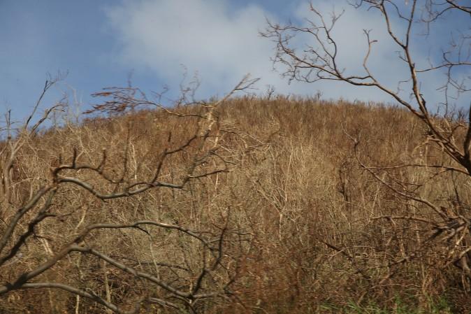
On the ground, it is easy to see the damage to foliage Hurricane Irma brought to Philipsburg, St. Maarten, stripping this entire area of its leaves, in this after photo taken on Sept.11, 2017. (Jose Jimenez/Getty Images)
On the ground, it is easy to see the damage to foliage Hurricane Irma brought to Philipsburg, St. Maarten, stripping this entire area of its leaves, in this after photo taken on Sept.11, 2017. Jose Jimenez/Getty Images
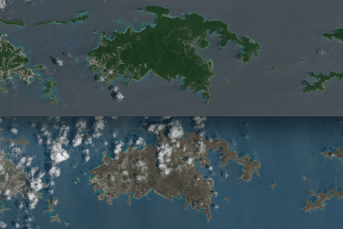
A series of before and after photos from NASA reveal that Hurricane Irma has changed the entire landscape of many  Caribbean islands.

The photos are undoctored and natural-colored.

“Differences in ocean color likely stem from differences in the ocean surface; rougher surfaces scatter more light, and appear brighter and lighter,” says NASA.
The top photo, taken Aug. 25, captures the vibrant green landscape of several U.S. and British Virgin Islands. The bottom photo, taken Sept. 10, reveals a dramatic change in color after Irma. The difference in ocean color is due to waves, said NASA. (NASA via Landsat 8 satellite)
The top photo, taken Aug. 25, captures the vibrant green landscape of several U.S. and British Virgin Islands. The bottom photo, taken Sept. 10, reveals a dramatic change in color after Irma. The difference in ocean color is due to waves, said NASA. NASA via Landsat 8 satellite
These U.S. and British Virgin Islands were slammed by Irma on and around Sept. 6, when Irma was at its most intense in the region.
The before pictures reveal a green landscape, capturing the lush plant life that blanketed much of these tropical islands on Aug. 25.
The after pictures, taken Sept. 10th, reveal the green landscape muted by brown and green.
“There are a number of possible reasons for this. Lush green tropical vegetation can be ripped away by a storm’s strong winds, leaving the satellite with a view of more bare ground. Also, salt spray whipped up by the hurricane can coat and desiccate leaves while they are still on the trees,” said NASA.
A closeup of Virgin Gorda reveals the same dramatic change before and after Hurricane Irma. (NASA via Landsat 8 satellite)
A closeup of Virgin Gorda reveals the same dramatic change before and after Hurricane Irma. NASA via Landsat 8 satellite
The photos captured by the Operational Land Imager (OLI) on the Landsat 8 satellite.
“They are among the few relatively cloud-free satellite images of the area so far,” said NASA.
The British Virgin Islands, which are more northern than the U.S. Virgin Islands, took more of Irma’s assault, though all of the islands suffered the effects of the storm.

The difference between the northern island of Barbuda and the southern island of Antiqua reveals the difference Irma made.

While Barbuda (top) was ravaged by Hurricane Irma, Antigua was spared the brunt of the storm and left wet, but much less severely damaged. (NASA via the MODIS spectroradiometer on the Terra and Aqua satellites)
While Barbuda (top) was ravaged by Hurricane Irma, Antigua was spared the brunt of the storm and left wet, but much less severely damaged. NASA via the MODIS spectroradiometer on the Terra and Aqua satellites
Matthew Little
Matthew Little
Author
Matthew Little is a senior editor with Epoch Health.
Related Topics