A technology that uses discarded mobile phones to create a real-time alert system against logging and poaching will soon be deployed in the endangered rainforests of Central Africa.
Rainforest Connection (RFCx), a San Francisco-based non-profit startup, is partnering with the Zoological Society of London (ZSL) to install its real-time anti-deforestation technology at sites in Cameroon. 30 RFCx devices — recycled from old Android handsets — will monitor 10,000 hectares or nearly 40 square miles of rainforest, listening for audio signals associated with logging and poaching. When the whir of a chainsaw, a gunshot, or the sound of a logging truck is detected, the system automatically alerts local authorities who can take action as the environmental crime is being committed.

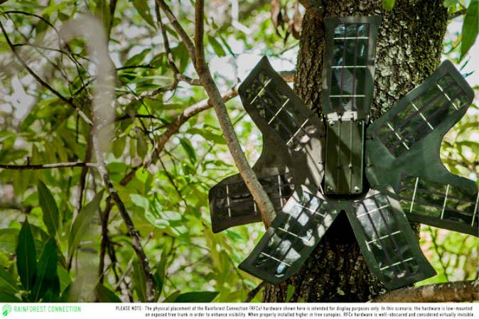
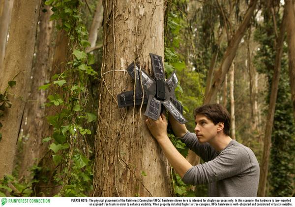
Rainforest Connection’s system is powered by a network of Android smartphones, each of which is driven by an array of solar panels that are designed for low-light conditions of the rainforest canopy. The units are durable to ensure they can survive hot and humid conditions for years. That durability, combined with the low cost of the units and the increasing ubiquity of mobile networks, means that the potential of the system is vast, according to Rainforest Connection founder Topher White.
“It’s clear that real-time awareness and intervention is a major missing piece in protecting the world’s last remaining rainforests,” said White in a statement. “By using old smartphones and existing telecommunications infrastructure, we have built a system that should scale quickly enough to make an impact.”
Rainforest Connection field-tested the system last year in Indonesia’s West Sumatra. While that project was intended only to probe the feasibility of the system, it immediately served its broader purpose, catching illegal loggers in the act two weeks after it was installed. White says the loggers haven’t returned in the year since.
“We have shown (in this one case) that knowledge of the system has deterred logging activity in the protected area,” he told Mongabay.com.
In Cameroon, the system will be listening for a number of sounds, including off-hours movement of trucks, which could indicate timber smuggling.
“To be blunt,” said White, “providing an accounting for corruption within the concession—including illegal logging by those who work there—is amongst the primary goals of the pilot.”
The sensors will also try to pick up elephants as they move through the forest.
ZSL, which operates projects across the tropics, says it excited about the prospect of real-time monitoring.
“We think this could be a critical new tool for protecting large areas of rainforest,” Chris Ransom, Programme Manager for ZSL. “We’re excited to deploy it this year in collaboration with our local partners in Africa.”
Rainforest Connection is hoping to scale the platform well beyond Cameroon and West Sumatra. Coinciding with the announcement of the ZSL partnership, Rainforest Connection launched a $100,000 KickStarter campaign that would support deployment in African and South American rainforests. Beyond knowing that they are helping protect endangered forests and animals, supporters can receive various rewards, including instructions on how to build their own RFCx device.
The potential payback of the system is immense. White estimates that RFCx device offers the greenhouse gas emissions-equivalent to taking 3,000 cars off the road for a year.

Courtesy of Rainforest Connection
“Each RFCx device ‘protects’ 300 hectares,” he explained. “Emissions from logging are 50 tons of carbon dioxide per hectare, translating to 15,000 tons per device.”
Rainforest Connection’s tool is part of an emerging suite of monitoring technologies that are being applied to conservation. For example, authorities in places like Brazil are putting motion sensors on trees, while researchers globally are using camera traps and satellite imagery for a wide range of applications. Scientists are even outfitting hobbyist model airplanes outfitted with sensors and cameras to track wildlife, find poachers, and detect deforestation and fires.
White says he hopes to extend Rainforest Connection’s capabilities leveraging some of these technologies.
“We are considering extending our range with small long-distance fixed-wing drones, which can fly-by several times per day and pick up data in bulk, re-transmitting it when they come within GSM range,” he said.
White discussed his efforts and more in a June 2014 interview with Mongabay.com.
An Interview With Topher White
Topher White (Courtesy of Topher White)
Mongabay.com: What led you to start Rainforest Connection?
Topher White: Rainforest Connection started because of a single event, in 2011, when I first witnessed illegal logging in Indonesian Borneo. I had travelled to Borneo as an eco-tourist to volunteer with a local NGO, Kalaweit, which is well-known for their work in rehabilitating formerly captive gibbons. Kalaweit’s mission includes the protection of a 40000 hectare reserve bordering upon their primary site, and they had invested significantly in helping to hire rangers to guard it. One day, our group was taken on a guided walking tour in the reserve, and within 5 minutes walk from the rangers’ HQ, we came upon a group of illegal loggers. They fled upon our arrival, but the problem was evident: even within relatively short distances, rangers had no real-time awareness of destructive activity in their reserve. While the limitations of their reach was certainly sympathetic, I found myself unable to accept it—I immediately knew that simple technology could solve the detection problem. Furthermore, I noticed that even in the jungle, bereft of electricity and perhaps a hundred miles from the nearest road, there was quite reliable cell service. And the populations there had come to rely upon it. That was when the solution to this one aspect of the overall problem became very clear.
Originally, I built this technology to help a friend—Chanee, of Kalaweit. Along the way, I noticed that many other people needed it too. It became clear to me that the technical expertise available in Silicon Valley could be easily utilized to address serious environmental problems which persist simply because no such expertise is available locally to solve them. And on the flip side, we'd be giving great minds here in California inspiring problems to solve—problems more profound than cutting down taxi wait times and building another social app. And that’s why I founded Rainforest Connection!
Mongabay.com: What audio signatures does your system listen for?
Topher White: The devices in the field actually record all sound and transmit it to our cloud API. The analysis is done in the cloud, for a few important reasons:
- It reduces the amount of CPU power used by the phones, allowing me to further “underclock” them and conserve energy. (note, conserving energy is always the single biggest engineering priority)
- It allows us archive sound as it arrives, and potentially go back into the archive and re-analyze past events. On the phones, no such option would be possible
- On a server we have much more flexible and powerful analysis tools at our disposal.
That said, the analysis for chainsaws is pretty straightforward. See attached plot.

If you look at that plot, just know that the spike are what indicate the presence of the chainsaw. The big spikes in the spectrum image are:
220 Hertz, 440 Hertz, 660 Hertz, 880 Hertz
They are harmonics of the resonant frequency (110 Hertz) of the chainsaw’s internal combustion engine. The recording for that spectrum comes from about one-half mile away (the device was one-half mile from the source of the chainsaw noise).
RFCx determines the presence of a chainsaw by doing “guaussian fits” at those four frequencies and sending alerts when multiple harmonics have low uncertainty in the fits. It’s actually very low tech, and only could really work with chainsaws and vehicles.
Mongabay.com: During your pilot project in West Sumatra what were some examples of the system in action? And where were the alerts sent?
Topher White: The pilot in Sumatra can really only be cited as a proof-of-concept for the technology itself, including its ability to detect and send immediate alerts in the remote forest, and to survive indefinitely despite poor lighting and harsh environment. It worked in detecting illegal logging, and we managed to arrive in time to interrupt it.
That said, at this time, our pilot has not yet proven the social efficacy of the system. Even though our partner, Kalaweit, has not experienced any logging intrusions since, the reserve itself is quite small (less 140 hectares). We have shown (in this one case) that knowledge of the system has deterred logging activity in the protected area, but it’s hard to know if this sort of thing could scale. Kalaweit only has that one small reserve, so we are having to pursue other partnerships to expand our system elsewhere in Indonesia.
Mongabay.com: Do you have concerns with theft of the equipment?
Topher White: When installed in the field, the devices are well camouflaged and nearly invisible in the tree canopy. The photos of the device that accompany the press release (low-mounted on trees) are solely for display purposes, because you can’t show a “hidden device.” If a device is properly placed high in the canopy, it’s very difficult to see—made even more undetectable by the 2-3 square kilometer range (many many thousands of trees) which are covered by a single device. Different rainforests have different attributes, but in Indonesia we could barely find the devices after we put them up ourselves.
There is also an anti-theft system built into the software of the devices. Because the sources are supposed to be stationary, they will never transmit their GPS coordinates unless a phone believes it has been stolen/compromised. All phones have accelerometers for determining orientation of the screen, and under normal circumstances the readings of the accelerometer should never change (if it’s nailed to a tree). If it gets moved, though, the accelerometer readings will trigger the activation of the GPS, which will begin tracking the phone and sending the info to our central API. So, GPS only under emergency-type situations.
Mongabay.com: How is your equipment powered?
Topher White: In building a system capable of producing more power than it uses within the unreliably lit tree canopy, we had to develop a few unique techniques. Nearly all solar panels technologies generally perform very poorly in indirect lighting, and standard panel configurations do not produce adequate power in shadowy conditions. If any portion of the panel (even just 5-10%) is covered by shadow, it can block the current generated by the rest of the panel. Under the tree canopy, the lighting conditions are unpredictable and sporadic—rays of direct light (sunflecks) break through the canopy for brief minutes or seconds, while the vast majority of the panels are bound to be covered in shadow. Sunfleck represent as much as 90% of the solar energy that makes it into the canopy, and so we had to envision, design, and test a new type of panel configuration that was able to maximize the energy produced by these sunflecks, while not drastically suffering from the vast majority of shadow. This also had to be done while keeping costs affordable and without becoming reliant upon non-mainstream solar technologies.
Mongabay.com: Does the system only work where there is a mobile phone signal?
Topher White: In terms of where we stand today, for our system to operate in real-time, at least a low-level of cell-service is required. Typically, it’s less than “one-bar”, so-to-speak (or, less than is necessary for a phone call). We also have some low-tech methods to exceed the expected range of coverage (to 30-50km), by placing devices higher in trees, and using inexpensive directional antennas. In other cases, where the range of cell service is even worse (such as one of our expected near-term deployments in the Tembe region in Brazil’s coastal Amazon) we are considering extending our range with small long-distance fixed-wing drones, which can fly-by several times per day and pick up data in bulk, re-transmitting it when they come within GSM range (or alternative uplink).
It’s also worth noting that our system is really designed to address the “90% case”. That is to say, we believe that by focusing only on “forested areas that have GSM coverage” we can build a more scalable solution at a small fraction of the cost/risk of a more universal solution. Expensive, high-tech contemporaries to Rainforest Connection abound (satellite-imagery, satellite-uplinked camera traps, etc) but scalability/costs of such systems are prohibitive at a large scale. If Rainforest Connection can build a solution from “trash” (discarded cell phones and solar panel by-products) that works cheaply in a majority of situations, it would be a great victory.
Mongabay.com: In Cameroon where is the system going to be used and where will alerts be directed?
Topher White: Our local partner is ZSL’s long-time partner SFID, a sustainable logging company whose concession is about 7000 sq km. In our initial deployment, RFCx will be protecting about 100km2 using about 30 devices in total.
SFID officers will be the primary recipients of the alerts. This will represent our first use of our new ranger-oriented mobile app and SMS/dumbphone app for responding to alerts and providing feedback.
Beyond chainsaws, we will also be detecting vehicle movements along roads, allowing authorities to note when trucks are moving logs on roads where (or when) no such activity is planned or sanctioned. To be blunt, providing an accounting for corruption within the concession—including illegal logging by those who work there—is amongst the primary goals of the pilot.
Most of the collaborations between ZSL and SFID are funded through grants from an inter-governmental collaboration in the Congo-Basin named PPECF-COMIFAC. We are told that PPECF are primarily funded by German development bank, KfW Entwicklungsbank.
At the request of ZSL and PPECF-COMIFAC, We are also going to attempt to track elephants in the concession using sound.
Mongabay.com: Are you developing other applications for your system?
Topher White:We can collect and analyze any data that a smartphone has a sensor for—though bandwidth would certainly limit streaming video or many photos.
On the other side of the equation, we are developing and plan to release a mobile app in late 2014 for streaming live audio from the rainforest. This is part of the reward collection in our Kickstarter campaign and has already attracted several backers.
I’m most exciting about that possibility because it opens the door to real-time engagement of people here in the US towards rainforest environmental issues that are necessarily abstract and difficult to grasp. One example: “an alert would be sent to subscribers when a specific species is detected in an area for the first time. They would then be able to listen in real-time to the sounds of that animal.” Weakly stated, but I hope the idea is clear enough.
Republished with permission from Mongabay.com. Read the original.
